1950s Maps of Alta, Utah
Explore 4 historic maps of Alta from the 1950s. These maps offer a rare glimpse into what life looked like during the 1950s — showing old roads, neighborhoods, homes, and landmarks that have changed or disappeared over time.
Whether you're researching your family's past, planning a metal detecting trip, or studying how Alta's landscape evolved across the 1950s, these high-resolution maps are a powerful tool for exploring the history of this region.
- Focus on a specific era: All maps on this page are from the 1950s, giving you a focused view of this time period.
- See what’s changed: Compare century-old streets, trails, and buildings to today's modern landscape using overlays and satellite layers.
- Research with precision: Use these maps for genealogy, historical research, land use analysis, or educational projects.
- View, download, or print: Maps are fully viewable online in high resolution, and can be downloaded or printed for your own records.
Start exploring Alta's history through authentic maps from the 1950s. This is your window into the past.
Alta, UT maps
(4)- 1954 Map of Salt Lake City, 1964 Print
 1954 Salt Lake City1964 Print · USGSThe Wasatch Front and Uinta Mountains are captured here in the mid-fifties, showing the industrial heart of Utah and its high mountain wilderness. Researchers can locate vanished infrastructure and landmarks like the Geneva Steel Plant, Bingham Canyon Mine, and the Utah State Prison.4 unique versions available
 - 1955 Map of Brighton, 1957 Print
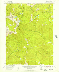 1955 Brighton1957 Print · USGSThe high Wasatch peaks are captured in the mid-1950s as a landscape defined by deep-shaft mining and emerging alpine recreation. Researchers can trace historic extraction sites like the Daly West Mine and Dutchman Mine alongside early camps such as Redman Forest Camp.4 unique versions available
 - 1955 Map of Dromedary Peak, 1957 Print
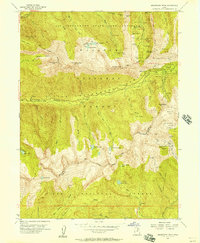 1955 Dromedary Peak1957 Print · USGSThe silver mining district around Alta reached a period of transition in the mid-1950s, as traditional claims met modern wilderness management. Researchers can trace decades of subterranean history through detailed labels for the Cardiff Mine, Emma Tunnel, and Flagstaff Mine.6 unique versions available
 - 1958 Map of Salt Lake City
 1958 Salt Lake City1958 Print · USGSThe Wasatch Front and Uinta Basin are captured during a period of significant post-war growth and industrial development. Researchers can trace the mid-century rail lines of the Bamberger RR and locate sites like the Kiegley Limestone Quarry and Camp Williams Military Reservation.
End of results
Showing maps 1-4 of 4
Top cities near Alta
- Salt Lake City historical maps
- Sandy historical maps
- Lehi historical maps
- Millcreek historical maps
- Murray historical maps
- Draper historical maps
See more
Frequently asked questions
- What are the different types of historical maps available for Alta?
- What is the oldest map of Alta?
- Where can I purchase historical maps of Alta for my home or office?
- Where can I download high-res historical maps of Alta?
- Are there historical topographic maps available for Alta?
- Is there historical aerial imagery available for Alta?
- Where are historical maps of Alta sourced from?