1990s Maps of Alta, Utah
Explore 2 historic maps of Alta from the 1990s. These maps offer a rare glimpse into what life looked like during the 1990s — showing old roads, neighborhoods, homes, and landmarks that have changed or disappeared over time.
Whether you're researching your family's past, planning a metal detecting trip, or studying how Alta's landscape evolved across the 1990s, these high-resolution maps are a powerful tool for exploring the history of this region.
- Focus on a specific era: All maps on this page are from the 1990s, giving you a focused view of this time period.
- See what’s changed: Compare century-old streets, trails, and buildings to today's modern landscape using overlays and satellite layers.
- Research with precision: Use these maps for genealogy, historical research, land use analysis, or educational projects.
- View, download, or print: Maps are fully viewable online in high resolution, and can be downloaded or printed for your own records.
Start exploring Alta's history through authentic maps from the 1990s. This is your window into the past.
Alta, UT maps
(2)- 1998 Map of Brighton, 2001 Print
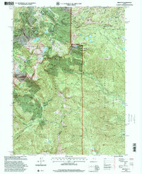 1998 Brighton2001 Print · USGSThe high Wasatch Range in the late nineties shows the convergence of alpine recreation and historic silver mining. Trace the shafts of the Daly West Mine and Flagstaff Mine or locate the Silver Lake Info and Rec Area at Brighton.
 - 1998 Map of Dromedary Peak, 2001 Print
 1998 Dromedary Peak2001 Print · USGSThe high Wasatch Range at the close of the twentieth century reveals a rugged intersection of heavy mining history and mountain recreation. Local researchers can trace old tunnel systems and claims like the Wasatch Mine, Cardiff Mine, and the historic settlement at Alta.
End of results
Showing maps 1-2 of 2
Top cities near Alta
- Salt Lake City historical maps
- Sandy historical maps
- Lehi historical maps
- Millcreek historical maps
- Murray historical maps
- Draper historical maps
See more
Frequently asked questions
- What are the different types of historical maps available for Alta?
- What is the oldest map of Alta?
- Where can I purchase historical maps of Alta for my home or office?
- Where can I download high-res historical maps of Alta?
- Are there historical topographic maps available for Alta?
- Is there historical aerial imagery available for Alta?
- Where are historical maps of Alta sourced from?