1950s Maps of Midvale, Utah
Explore 6 historic maps of Midvale from the 1950s. These maps offer a rare glimpse into what life looked like during the 1950s — showing old roads, neighborhoods, homes, and landmarks that have changed or disappeared over time.
Whether you're researching your family's past, planning a metal detecting trip, or studying how Midvale's landscape evolved across the 1950s, these high-resolution maps are a powerful tool for exploring the history of this region.
- Focus on a specific era: All maps on this page are from the 1950s, giving you a focused view of this time period.
- See what’s changed: Compare century-old streets, trails, and buildings to today's modern landscape using overlays and satellite layers.
- Research with precision: Use these maps for genealogy, historical research, land use analysis, or educational projects.
- View, download, or print: Maps are fully viewable online in high resolution, and can be downloaded or printed for your own records.
Start exploring Midvale's history through authentic maps from the 1950s. This is your window into the past.
Midvale, UT maps
(6)- 1951 Map of Salt Lake City South, 1953 Print
 1951 Salt Lake City South1953 Print · USGSThe Salt Lake Valley undergoes post-war expansion in the early fifties as the urban grid begins to overtake surrounding farmlands. Trace the development of Murray and Kearns, and locate historic landmarks like the Taylorsville Cemetery and Falcon Field.
 - 1951 Map of Midvale, 1953 Print
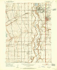 1951 Midvale1953 Print · USGSThe Salt Lake Valley in the early fifties shows a landscape of busy rail corridors and irrigation canals before the onset of modern suburban sprawl. Trace the industrial heritage of the Sugar Factory or locate family roots near Jordan High Sch and the Midvale rail sidings.
 - 1952 Map of Sugar House, 1954 Print
 1952 Sugar House1954 Print · USGSSalt Lake City's eastern suburbs and the rugged Wasatch front are captured here in the early fifties as the city expanded toward the mountains. Researchers can find the State Prison (Abandoned), the Hogle Garden Zoo, and the industrial Brick Kilns near the D & R G W RR line.2 unique versions available
 - 1952 Map of Draper, 1954 Print
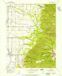 1952 Draper1954 Print · USGSThe Salt Lake Valley at the start of the fifties reveals a landscape of irrigation canals, early private airfields, and rail spurs. Genealogists and local historians can trace the foundations of Draper, Union, and Sandy, or locate the Union Cemetery and the Historic Mon Temple Granite Quarry.2 unique versions available
 - 1954 Map of Salt Lake City, 1964 Print
 1954 Salt Lake City1964 Print · USGSThe Wasatch Front and Uinta Mountains are captured here in the mid-fifties, showing the industrial heart of Utah and its high mountain wilderness. Researchers can locate vanished infrastructure and landmarks like the Geneva Steel Plant, Bingham Canyon Mine, and the Utah State Prison.4 unique versions available
 - 1958 Map of Salt Lake City
 1958 Salt Lake City1958 Print · USGSThe Wasatch Front and Uinta Basin are captured during a period of significant post-war growth and industrial development. Researchers can trace the mid-century rail lines of the Bamberger RR and locate sites like the Kiegley Limestone Quarry and Camp Williams Military Reservation.
End of results
Showing maps 1-6 of 6
Top cities near Midvale
- Salt Lake City historical maps
- West Valley City historical maps
- West Jordan historical maps
- Sandy historical maps
- Lehi historical maps
- South Jordan historical maps
See more
Top neighborhoods of Midvale
Frequently asked questions
- What are the different types of historical maps available for Midvale?
- What is the oldest map of Midvale?
- Where can I purchase historical maps of Midvale for my home or office?
- Where can I download high-res historical maps of Midvale?
- Are there historical topographic maps available for Midvale?
- Is there historical aerial imagery available for Midvale?
- Where are historical maps of Midvale sourced from?