1990s Maps of Midvale, Utah
Explore 4 historic maps of Midvale from the 1990s. These maps offer a rare glimpse into what life looked like during the 1990s — showing old roads, neighborhoods, homes, and landmarks that have changed or disappeared over time.
Whether you're researching your family's past, planning a metal detecting trip, or studying how Midvale's landscape evolved across the 1990s, these high-resolution maps are a powerful tool for exploring the history of this region.
- Focus on a specific era: All maps on this page are from the 1990s, giving you a focused view of this time period.
- See what’s changed: Compare century-old streets, trails, and buildings to today's modern landscape using overlays and satellite layers.
- Research with precision: Use these maps for genealogy, historical research, land use analysis, or educational projects.
- View, download, or print: Maps are fully viewable online in high resolution, and can be downloaded or printed for your own records.
Start exploring Midvale's history through authentic maps from the 1990s. This is your window into the past.
Midvale, UT maps
(4)- 1998 Map of Sugar House, 2001 Print
 1998 Sugar House2001 Print · USGSSalt Lake City and Murray expand toward the Wasatch Front in the late nineties as the suburban grid meets the wilderness. Trace local heritage at Wheeler Historic Farm, the Sugar House Monument, or find family records at Elysian Burial Gardens and Knudsens Corner.
 - 1998 Map of Draper, 2001 Print
 1998 Draper2001 Print · USGSSandy City and Draper are shown during a period of rapid suburban expansion in the late nineties, right up to the edge of the wilderness. Researchers can trace the development of local neighborhoods alongside landmarks like Union Cem, Granite, and Mellen Sand Spur.
 - 1999 Map of Salt Lake City South, 2001 Print
 1999 Salt Lake City South2001 Print · USGSSalt Lake Valley settlement reached a peak of suburban development by the late nineties, filling the space between the river and the western benches. Researchers can trace the evolution of neighborhoods like Taylorsville and Kearns, or locate landmarks such as Franklin Covey Field and Redwood Mem Estates.
 - 1999 Map of Midvale, 2001 Print
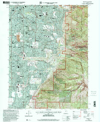
 1999 Midvale2001 Print · USGSThe Salt Lake Valley at the turn of the millennium reveals a landscape of rapid suburban growth and major public institutions. Genealogists and local historians can trace family locations near the South Jordan Cemetery or find early school sites like Oquirrh Sch and Welby Sch.
End of results
Showing maps 1-4 of 4
Top cities near Midvale
- Salt Lake City historical maps
- West Valley City historical maps
- West Jordan historical maps
- Sandy historical maps
- Lehi historical maps
- South Jordan historical maps
See more
Top neighborhoods of Midvale
Frequently asked questions
- What are the different types of historical maps available for Midvale?
- What is the oldest map of Midvale?
- Where can I purchase historical maps of Midvale for my home or office?
- Where can I download high-res historical maps of Midvale?
- Are there historical topographic maps available for Midvale?
- Is there historical aerial imagery available for Midvale?
- Where are historical maps of Midvale sourced from?