1900s (20th Century) Maps of Clay Hills Crossing, Utah
Explore 6 historic maps of Clay Hills Crossing from the 1900s (20th Century). These maps offer a rare glimpse into what life looked like during the 1900s — showing old roads, neighborhoods, homes, and landmarks that have changed or disappeared over time.
Whether you're researching your family's past, planning a metal detecting trip, or studying how Clay Hills Crossing's landscape evolved across the 1900s, these high-resolution maps are a powerful tool for exploring the history of this region.
- Focus on a specific era: All maps on this page are from the 1900s, giving you a focused view of this time period.
- See what’s changed: Compare century-old streets, trails, and buildings to today's modern landscape using overlays and satellite layers.
- Research with precision: Use these maps for genealogy, historical research, land use analysis, or educational projects.
- View, download, or print: Maps are fully viewable online in high resolution, and can be downloaded or printed for your own records.
Start exploring Clay Hills Crossing's history through authentic maps from the 1900s. This is your window into the past.
Clay Hills Crossing, UT maps
(6)- 1954 Map of Clay Hills 2 SW, 1955 Print
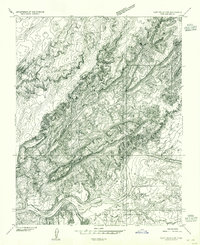 1954 Clay Hills 2 SW1955 Print · USGSThe San Juan River canyonlands in the mid-fifties reveal a remote landscape of Navajo lands and river crossings. Researchers can trace the layout of Piute Farms, locate isolated dwellings at Hagans and Hogan, or find the historic Clay Hills Crossing.
 - 1954 Map of Clay Hills, 1957 Print
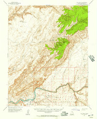 1954 Clay Hills1957 Print · USGSThe San Juan River boundary and the high plateaus of southern Utah are captured here in the mid-1950s. Researchers can locate remote desert outposts like Piute Farms and Rockhouse, or trace early access routes at Clay Hills Crossing.4 unique versions available
 - 1956 Map of Escalante
 1956 Escalante1956 Print · USGSSouthern Utah and Northern Arizona are charted here in the mid-fifties, just before the canyon floor was transformed. Researchers can trace remote desert commerce at Oljeto Trading Post, find the Adairville (ruins), and locate Uranium mines.5 unique versions available
 - 1960 Map of Escalante
 1960 Escalante1960 Print · USGSSouthern Utah and northern Arizona appear at a historic turning point in the late fifties as Lake Powell begins to reshape the canyons. Researchers can trace remote sites like Goulding Trading Post, a lonely Uranium Mine, and Coyote Ranches before the reservoir's rise.
 - 1981 Map of Navajo Mountain, 1982 Print
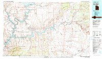 1981 Navajo Mountain1982 Print · USGSThe high desert border of Utah and Arizona is captured here in the early eighties, showing the sprawling waters of Lake Powell and the San Juan River. Researchers can locate the Sunwind Mine, the Navajo Mountain School, and the iconic Rainbow Bridge.
 - 1987 Map of Mikes Mesa
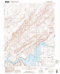 1987 Mikes Mesa1987 Print · USGSThe San Juan River and Lake Powell are captured here in the late eighties, showing the dramatic intersection of desert canyonlands and rising reservoir waters. Researchers can trace the shoreline and find landmarks like Clay Hills Crossing, Mikes Mesa, and the Red House Cliffs.2 unique versions available
End of results
Showing maps 1-6 of 6
Frequently asked questions
- What are the different types of historical maps available for Clay Hills Crossing?
- What is the oldest map of Clay Hills Crossing?
- Where can I purchase historical maps of Clay Hills Crossing for my home or office?
- Where can I download high-res historical maps of Clay Hills Crossing?
- Are there historical topographic maps available for Clay Hills Crossing?
- Is there historical aerial imagery available for Clay Hills Crossing?
- Where are historical maps of Clay Hills Crossing sourced from?