
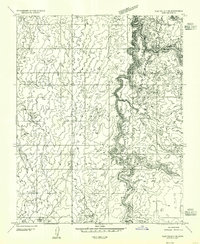
1954 Map of Clay Hills 2 SW
USGS Topo · Published 1955About this map
The San Juan River defines the southern reach of this canyon-heavy landscape, carving through the high plateau of San Juan County. This mid-century survey documents the northern edge of the Navajo Indian Reservation, where the river loops past the riverside settlement of Piute Farms. The terrain is characterized by steep contours and sharp relief, with a notable absence of major infrastructure, reflecting the isolation of the region before significant modern development.
Find a feature on this map
13 named features on this map. Tap any name to fly to it.
Don’t see what you’re looking for? This feature index may not catch every label — zoom into the map to look around manually.
Map Details
Editions of this 1954 Clay Hills 2 SW Map
This is the sole edition of this map. No revisions or reprints were ever made.
Other maps of this area

1886 · Henry Mountains
USGS Topo · 1:250,000

1892 · Henry Mountains
USGS Topo · 1:250,000

1952 · Clay Hills 3 NW
USGS Topo · 1:24,000

1952 · Navajo Mountain 4 NE
USGS Topo · 1:24,000

1952 · Oljeto
USGS Topo · 1:62,500

1953 · Lake Canyon
USGS Topo · 1:62,500

1953 · No Mans Mesa
USGS Topo · 1:62,500

1954 · Clay Hills 2 NW
USGS Topo · 1:24,000
1954 · Clay Hills 3 NE
USGS Topo · 1:24,000

1954 · Clay Hills 2 NE
USGS Topo · 1:24,000