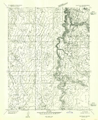
1954 Map of Clay Hills 3 NE
USGS Topo · Published 1955About this map
The Navajo Indian Reservation landscape is meticulously detailed in this preliminary survey, which was mapped in the mid-1950s using aerial photography. The geography is defined by the winding course of Oljeto Wash, which carves a deep, intricate drainage pattern through the high desert terrain of San Juan County. This specific quadrant highlights the essential role of water management in an arid environment, featuring the Rock Dam Reservoir in the southern reaches and a solitary Spring tucked into the topography. The map illustrates a period of transition for the region, produced as a precursor to more comprehensive 15-minute series mapping, and focuses primarily on the natural landforms and hydrology of this remote corner of the Navajo Indian Reservation.
Find a feature on this map
6 named features on this map. Tap any name to fly to it.
Don’t see what you’re looking for? This feature index may not catch every label — zoom into the map to look around manually.
Map Details
Editions of this 1954 Clay Hills 3 NE Map
This is the sole edition of this map. No revisions or reprints were ever made.
Other maps of this area

1886 · Henry Mountains
USGS Topo · 1:250,000

1892 · Henry Mountains
USGS Topo · 1:250,000

1952 · Clay Hills 4 SW
USGS Topo · 1:24,000

1952 · Clay Hills 3 SE
USGS Topo · 1:24,000

1952 · Clay Hills 3 SW
USGS Topo · 1:24,000

1952 · Clay Hills 3 NW
USGS Topo · 1:24,000

1952 · Oljeto
USGS Topo · 1:62,500

1954 · Clay Hills 2 SW
USGS Topo · 1:24,000

1954 · Clay Hills 2 SE
USGS Topo · 1:24,000
1954 · Clay Hills
USGS Topo · 1:62,500