
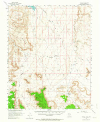
1952 Map of Oljeto
USGS Topo · Published 1957About this map
Monument Valley terrain defines this mid-century survey of the Navajo Indian Reservation, spanning the border of Utah and Arizona. The landscape is dominated by high-desert features like Hoskinnini Mesa and Oljeto Mesa, dissected by an intricate network of drainage systems including Piute Farms Wash, Oljeto Wash, and Copper Canyon.
Find a feature on this map
32 named features on this map. Tap any name to fly to it.
Don’t see what you’re looking for? This feature index may not catch every label — zoom into the map to look around manually.
Map Details
Editions of this 1952 Oljeto Map
2 editions found
Other maps of this area

1883 · Marsh Pass
USGS Topo · 1:250,000

1886 · Henry Mountains
USGS Topo · 1:250,000

1892 · Marsh Pass
USGS Topo · 1:250,000

1892 · Henry Mountains
USGS Topo · 1:250,000

1952 · Clay Hills 4 SW
USGS Topo · 1:24,000

1952 · Clay Hills 3 SE
USGS Topo · 1:24,000

1952 · Shato Spring 1 NE
USGS Topo · 1:24,000

1952 · Agathla Peak 1 NW
USGS Topo · 1:24,000

1952 · Agathla Peak 2 NW
USGS Topo · 1:24,000

1952 · Boot Mesa
USGS Topo · 1:62,500