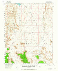
1952 Map of Oljeto
USGS Topo · Published 1964About this map
Monitor Butte and the vast sandstone formations of the Navajo Indian Reservation dominate this mid-century survey of the Utah-Arizona border. The landscape is defined by its massive plateaus and deeply cut drainage systems, including Oljeto Wash and the winding Copper Canyon. Significant for its cold-war era industrial context, the map shows the Whirlwind Mine and a remote Landing Strip, likely reflecting uranium exploration conducted in cooperation with the Atomic Energy Commission during the early 1950s. At the northern edge, Lake Powell is depicted in blue, indicating areas to be submerged by the reservoir. This transition from a traditional desert landscape to a managed waterway is captured alongside established landmarks like Jacobs Monument and the massive Hoskinnini Mesa. Transportation is limited to a few rugged routes, such as the Wetherill Trail and various unnamed jeep trails, highlighting the isolation of the Oljeto settlement at this time.
Find a feature on this map
34 named features on this map. Tap any name to fly to it.
Don’t see what you’re looking for? This feature index may not catch every label — zoom into the map to look around manually.
Map Details
Editions of this 1952 Oljeto Map
2 editions found

Other maps of this area

1883 · Marsh Pass
USGS Topo · 1:250,000

1886 · Henry Mountains
USGS Topo · 1:250,000

1892 · Marsh Pass
USGS Topo · 1:250,000

1892 · Henry Mountains
USGS Topo · 1:250,000

1952 · Clay Hills 4 SW
USGS Topo · 1:24,000

1952 · Clay Hills 3 SE
USGS Topo · 1:24,000

1952 · Shato Spring 1 NE
USGS Topo · 1:24,000

1952 · Agathla Peak 1 NW
USGS Topo · 1:24,000

1952 · Agathla Peak 2 NW
USGS Topo · 1:24,000

1952 · Boot Mesa
USGS Topo · 1:62,500