1900s (20th Century) Maps of Goulding's, Utah
Explore 6 historic maps of Goulding's from the 1900s (20th Century). These maps offer a rare glimpse into what life looked like during the 1900s — showing old roads, neighborhoods, homes, and landmarks that have changed or disappeared over time.
Whether you're researching your family's past, planning a metal detecting trip, or studying how Goulding's's landscape evolved across the 1900s, these high-resolution maps are a powerful tool for exploring the history of this region.
- Focus on a specific era: All maps on this page are from the 1900s, giving you a focused view of this time period.
- See what’s changed: Compare century-old streets, trails, and buildings to today's modern landscape using overlays and satellite layers.
- Research with precision: Use these maps for genealogy, historical research, land use analysis, or educational projects.
- View, download, or print: Maps are fully viewable online in high resolution, and can be downloaded or printed for your own records.
Start exploring Goulding's's history through authentic maps from the 1900s. This is your window into the past.
Goulding's, UT maps
(6)- 1952 Map of Clay Hills 4 SW
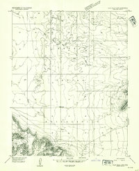 1952 Clay Hills 4 SW1952 Print · USGSSan Juan County in the early fifties reveals a remote landscape where tradition meets industry on the Navajo Indian Reservation. Researchers can trace the layout of the Goulding Trading Post, the remote Skyline Mine, and scattered dwellings labeled simply as Hogans.2 unique versions available
 - 1956 Map of Escalante
 1956 Escalante1956 Print · USGSSouthern Utah and Northern Arizona are charted here in the mid-fifties, just before the canyon floor was transformed. Researchers can trace remote desert commerce at Oljeto Trading Post, find the Adairville (ruins), and locate Uranium mines.5 unique versions available
 - 1960 Map of Escalante
 1960 Escalante1960 Print · USGSSouthern Utah and northern Arizona appear at a historic turning point in the late fifties as Lake Powell begins to reshape the canyons. Researchers can trace remote sites like Goulding Trading Post, a lonely Uranium Mine, and Coyote Ranches before the reservoir's rise.
 - 1963 Map of Goulding, 1965 Print
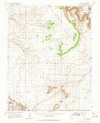 1963 Goulding1965 Print · USGSThe high desert along the Utah-Arizona border comes to life in the early sixties, showing the remote outposts of the Monument Valley region. Trace the locations of the Goulding Trading Post, the Mission, and geologic icons like Castle Rock and Sentinel Mesa.2 unique versions available
 - 1981 Map of Navajo Mountain, 1982 Print
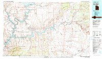 1981 Navajo Mountain1982 Print · USGSThe high desert border of Utah and Arizona is captured here in the early eighties, showing the sprawling waters of Lake Powell and the San Juan River. Researchers can locate the Sunwind Mine, the Navajo Mountain School, and the iconic Rainbow Bridge.
 - 1988 Map of Goulding
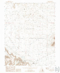 1988 Goulding1988 Print · USGSThe Navajo Indian Reservation comes into focus during the late 1980s, showing a landscape where remote mesas meet essential community infrastructure. Researchers can locate family landmarks and local industry, from the Skyline Mine and Goulding settlement to the Monument Valley High School.
End of results
Showing maps 1-6 of 6
Top cities near Goulding's
Frequently asked questions
- What are the different types of historical maps available for Goulding's?
- What is the oldest map of Goulding's?
- Where can I purchase historical maps of Goulding's for my home or office?
- Where can I download high-res historical maps of Goulding's?
- Are there historical topographic maps available for Goulding's?
- Is there historical aerial imagery available for Goulding's?
- Where are historical maps of Goulding's sourced from?