1900s (20th Century) Maps of Monticello, Utah
Explore 11 historic maps of Monticello from the 1900s (20th Century). These maps offer a rare glimpse into what life looked like during the 1900s — showing old roads, neighborhoods, homes, and landmarks that have changed or disappeared over time.
Whether you're researching your family's past, planning a metal detecting trip, or studying how Monticello's landscape evolved across the 1900s, these high-resolution maps are a powerful tool for exploring the history of this region.
- Focus on a specific era: All maps on this page are from the 1900s, giving you a focused view of this time period.
- See what’s changed: Compare century-old streets, trails, and buildings to today's modern landscape using overlays and satellite layers.
- Research with precision: Use these maps for genealogy, historical research, land use analysis, or educational projects.
- View, download, or print: Maps are fully viewable online in high resolution, and can be downloaded or printed for your own records.
Start exploring Monticello's history through authentic maps from the 1900s. This is your window into the past.
Monticello, UT maps
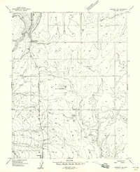
(11)- 1955 Map of Verdure 2 SE
 1955 Verdure 2 SE1955 Print · USGSSan Juan County at the midpoint of the century reveals the high-plateau character of Monticello and the nearby settlement of Verdure. Genealogists and historians can trace the early townsite grid, local landmarks like the High Sch, and rural landmarks including Bull Hollow.
 - 1956 Map of Cortez, 1972 Print
 1956 Cortez1972 Print · USGSThe Four Corners region comes alive in this mid-century study of the high plateaus and deep canyons surrounding Cortez. Trace the development of desert outposts like Towaoc or follow the historic Laramie Trail across a landscape dotted with ancient sites at Mesa Verde National Park.2 unique versions available
 - 1957 Map of Monticello, 1960 Print
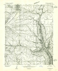
 1957 Monticello1960 Print · USGSMonticello and the eastern Abajo Mountains are captured here in the late fifties, just as the local uranium and ranching economies were evolving. Researchers can trace historic mining operations at the Gold Queen Mine, locate the Baker Ranger Sta, and identify early landmarks like Buckboard Camp and the Blue Mtn Ranch.2 unique versions available
 - 1958 Map of Verdure 2 NE
 1958 Verdure 2 NE1958 Print · USGSThe high plateau of San Juan County comes into focus during the late fifties, centered on the northern outskirts of Monticello. Researchers can trace old transportation routes like Spring Creek Road and identify water sources such as Keller Reservoir and Peters Spring.
 - 1958 Map of Cortez
 1958 Cortez1958 Print · USGSThe Four Corners region comes alive in the late fifties, showing the interplay between expanding mountain settlements and ancient archeological sites. Trace the layout of Cortez, Monticello, and Blanding alongside landmarks like Mesa Verde National Park and Fort Lewis A&M College.
 - 1959 Map of Cortez
 1959 Cortez1959 Print · USGSThe Four Corners region in the late fifties was a landscape of ancestral sites and isolated ranching outposts. Genealogists and historians can trace the early footprints of Cortez, Towaoc, and Mexican Hat alongside the canyons of the San Juan River.2 unique versions available
 - 1962 Map of Cortez
 1962 Cortez1962 Print · USGSThe Four Corners region comes alive in the early sixties, showing a landscape defined by reservation lands and federal forests. Trace the route of the Rio Grande Southern RR or locate the Uranium and vanadium mines near Monticello.
 - 1966 Map of Cortez
 1966 Cortez1966 Print · USGSThe Four Corners region in the mid-sixties reveals a landscape of high mesas, tribal lands, and archaeological preserves. Researchers can trace the ancient sites at Hovenweep National Monument, follow the Denver & Rio Grande Western Railroad, or locate old settlements like Ginger Hill and Yellow Jacket.
 - 1982 Map of Blanding, 1983 Print
 1982 Blanding1983 Print · USGSSoutheastern Utah and the Colorado borderlands are shown here in the early eighties, capturing the high-desert settlements of San Juan County. Researchers can trace local landmarks like Nancy Patterson Lake, the ranching community of Ucolo, and the remote Lockerby.
 - 1985 Map of Monticello South
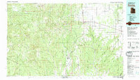
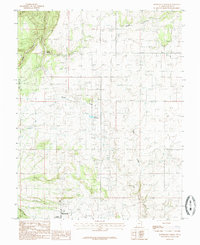
 1985 Monticello South1985 Print · USGSSan Juan County in the mid-1980s shows the transition from the high-plateau town of Monticello to the deep draws of the canyonlands. Researchers can locate the settlement of Verdure, a local Cem, and landmarks like Dodge Point and Montezuma Canyon.
 - 1985 Map of Monticello North
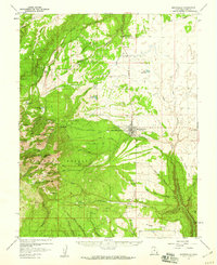
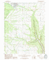
 1985 Monticello North1985 Print · USGSMonticello and the surrounding high plateau are captured in the mid-1980s as the town expanded near the national forest boundary. Researchers can locate specific infrastructure like the County Airport, the Keller Reservoir, and family-oriented landmarks such as the Rodeo grounds.
End of results
Showing maps 1-11 of 11
Top cities near Monticello
Frequently asked questions
- What are the different types of historical maps available for Monticello?
- What is the oldest map of Monticello?
- Where can I purchase historical maps of Monticello for my home or office?
- Where can I download high-res historical maps of Monticello?
- Are there historical topographic maps available for Monticello?
- Is there historical aerial imagery available for Monticello?
- Where are historical maps of Monticello sourced from?