1980s Maps of Old La Sal, Utah
Explore 2 historic maps of Old La Sal from the 1980s. These maps offer a rare glimpse into what life looked like during the 1980s — showing old roads, neighborhoods, homes, and landmarks that have changed or disappeared over time.
Whether you're researching your family's past, planning a metal detecting trip, or studying how Old La Sal's landscape evolved across the 1980s, these high-resolution maps are a powerful tool for exploring the history of this region.
- Focus on a specific era: All maps on this page are from the 1980s, giving you a focused view of this time period.
- See what’s changed: Compare century-old streets, trails, and buildings to today's modern landscape using overlays and satellite layers.
- Research with precision: Use these maps for genealogy, historical research, land use analysis, or educational projects.
- View, download, or print: Maps are fully viewable online in high resolution, and can be downloaded or printed for your own records.
Start exploring Old La Sal's history through authentic maps from the 1980s. This is your window into the past.
Old La Sal, UT maps
(2)- 1982 Map of La Sal, 1983 Print
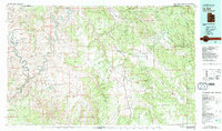 1982 La Sal1983 Print · USGSThe high desert of southeastern Utah meets the Colorado border in the early eighties, showing a landscape defined by deep canyons and mining. Trace the industrial operations at Lisbon Mine or explore the early mapping of The Needles and Island in the Sky.2 unique versions available
 - 1987 Map of La Sal East
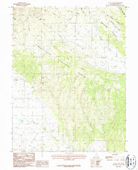 1987 La Sal East1987 Print · USGSSan Juan County’s high country is documented here in the late 1980s, showcasing a landscape of mining and forestry. Local historians can trace mining operations at the Snowball Mine and locate the historic settlement site of Old La Sal.2 unique versions available
End of results
Showing maps 1-2 of 2
Frequently asked questions
- What are the different types of historical maps available for Old La Sal?
- What is the oldest map of Old La Sal?
- Where can I purchase historical maps of Old La Sal for my home or office?
- Where can I download high-res historical maps of Old La Sal?
- Are there historical topographic maps available for Old La Sal?
- Is there historical aerial imagery available for Old La Sal?
- Where are historical maps of Old La Sal sourced from?