1900s (20th Century) Maps of Soldier Crossing, Utah
Explore 7 historic maps of Soldier Crossing from the 1900s (20th Century). These maps offer a rare glimpse into what life looked like during the 1900s — showing old roads, neighborhoods, homes, and landmarks that have changed or disappeared over time.
Whether you're researching your family's past, planning a metal detecting trip, or studying how Soldier Crossing's landscape evolved across the 1900s, these high-resolution maps are a powerful tool for exploring the history of this region.
- Focus on a specific era: All maps on this page are from the 1900s, giving you a focused view of this time period.
- See what’s changed: Compare century-old streets, trails, and buildings to today's modern landscape using overlays and satellite layers.
- Research with precision: Use these maps for genealogy, historical research, land use analysis, or educational projects.
- View, download, or print: Maps are fully viewable online in high resolution, and can be downloaded or printed for your own records.
Start exploring Soldier Crossing's history through authentic maps from the 1900s. This is your window into the past.
Soldier Crossing, UT maps
(7)- 1952 Map of Natural Bridges, 1954 Print
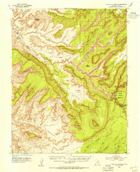 1952 Natural Bridges1954 Print · USGSSoutheast Utah at the dawn of the atomic age reveals a landscape defined by deep sandstone gorges and the early marks of uranium prospecting. Researchers can locate the iconic spans of Natural Bridges National Monument, archaeological sites like Water Jar Cave, and early river crossings at Soldier Crossing.3 unique versions available
 - 1954 Map of White Canyon 4 NW
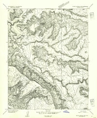 1954 White Canyon 4 NW1954 Print · USGSSan Juan County in the early fifties was a landscape defined by deep erosional drainages and essential desert water sources. Researchers can trace early routes through White Canyon via Soldier Crossing or locate landmarks like Jacobs Chair and Rock Spring.
 - 1956 Map of Escalante
 1956 Escalante1956 Print · USGSSouthern Utah and Northern Arizona are charted here in the mid-fifties, just before the canyon floor was transformed. Researchers can trace remote desert commerce at Oljeto Trading Post, find the Adairville (ruins), and locate Uranium mines.5 unique versions available
 - 1960 Map of Escalante
 1960 Escalante1960 Print · USGSSouthern Utah and northern Arizona appear at a historic turning point in the late fifties as Lake Powell begins to reshape the canyons. Researchers can trace remote sites like Goulding Trading Post, a lonely Uranium Mine, and Coyote Ranches before the reservoir's rise.
 - 1980 Map of Hite Crossing, 1987 Print
 1980 Hite Crossing1987 Print · USGSSouthern Utah's canyon country comes alive in the early eighties as the waters of Lake Powell reshape the landscape. Trace old mining operations like the Happy Jack Mine or the remote peaks of the Henry Mountains.
 - 1987 Map of Jacobs Chair
 1987 Jacobs Chair1987 Print · USGSSan Juan County at the close of the 1980s remains a landscape of deep canyons and massive desert mesas. Genealogists and historians can trace the paths through Soldier Crossing or locate remote landmarks like Jacobs Chair and the Fry Canyon Trailer Park.
 - 1996 Map of Jacobs Chair, 2002 Print
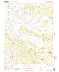 1996 Jacobs Chair2002 Print · USGSSan Juan County’s high desert landscape is documented here in the late twentieth century, showing a remote area shaped by deep canyons and mesas. Researchers can trace the layout of the Fry Canyon Trailer Park, the Landing Strip, and early exploration sites like Gravel Crossing.
End of results
Showing maps 1-7 of 7
Frequently asked questions
- What are the different types of historical maps available for Soldier Crossing?
- What is the oldest map of Soldier Crossing?
- Where can I purchase historical maps of Soldier Crossing for my home or office?
- Where can I download high-res historical maps of Soldier Crossing?
- Are there historical topographic maps available for Soldier Crossing?
- Is there historical aerial imagery available for Soldier Crossing?
- Where are historical maps of Soldier Crossing sourced from?