2000-2009 Maps of Fountain Green, Utah
Explore 2 historic maps of Fountain Green from 2000-2009. These maps offer a rare glimpse into what life looked like during the 2000s — showing old roads, neighborhoods, homes, and landmarks that have changed or disappeared over time.
Whether you're researching your family's past, planning a metal detecting trip, or studying how Fountain Green's landscape evolved across the 2000s, these high-resolution maps are a powerful tool for exploring the history of this region.
- Focus on a specific era: All maps on this page are from the 2000s, giving you a focused view of this time period.
- See what’s changed: Compare century-old streets, trails, and buildings to today's modern landscape using overlays and satellite layers.
- Research with precision: Use these maps for genealogy, historical research, land use analysis, or educational projects.
- View, download, or print: Maps are fully viewable online in high resolution, and can be downloaded or printed for your own records.
Start exploring Fountain Green's history through authentic maps from the 2000s. This is your window into the past.
Fountain Green, UT maps
(2)- 2001 Map of Fountain Green North, 2004 Print
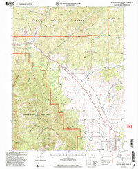 2001 Fountain Green North2004 Print · USGSThe Sanpete Valley meets the mountains of the Uinta National Forest at the turn of the millennium. Genealogists can locate the town Cem and local landmarks like the Fish Hatchery and Big Springs.
 - 2001 Map of Fountain Green South, 2004 Print
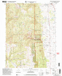 2001 Fountain Green South2004 Print · USGSThe Sanpete Valley remains a quiet agricultural landscape at the turn of the millennium, anchored by small settlements and high mountain ridges. Trace the routes of local families through Fountain Green, Freedom, and the nearby Cem.
End of results
Showing maps 1-2 of 2
Top cities near Fountain Green
- Nephi historical maps
- Mount Pleasant historical maps
- Moroni historical maps
- Mona historical maps
- Fairview historical maps
- Spring City historical maps
See more
Frequently asked questions
- What are the different types of historical maps available for Fountain Green?
- What is the oldest map of Fountain Green?
- Where can I purchase historical maps of Fountain Green for my home or office?
- Where can I download high-res historical maps of Fountain Green?
- Are there historical topographic maps available for Fountain Green?
- Is there historical aerial imagery available for Fountain Green?
- Where are historical maps of Fountain Green sourced from?