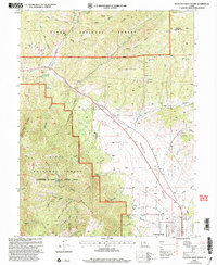
2001 Map of Fountain Green North
USGS Topo · Published 2004About this map
The Sanpete Valley floor meets the rising slopes of the San Pitch Mountains in this early 21st-century record of central Utah. The township of Fountain Green sits at the edge of the valley, where the agricultural landscape is supported by a network of water features including Big Springs and a local Fish Hatchery. The map documents a complex forest management boundary where the Uinta National Forest is administered by the Manti-La Sal National Forest, highlighting the administrative shifts in Utah's high country. This transition from valley to peak is marked by family-named canyons and hollows such as Jewkes Canyon and Bradley Canyon, illustrating how the local geography was carved out by early ranching and water rights. The Nebo Loop Scenic Byway winds through the northern peaks, providing modern access to the rugged Rocky Ridge and Rolley Ridge.
Find a feature on this map
37 named features on this map. Tap any name to fly to it.
Don’t see what you’re looking for? This feature index may not catch every label — zoom into the map to look around manually.
Map Details
Editions of this 2001 Fountain Green North Map
This is the sole edition of this map. No revisions or reprints were ever made.
Other maps of this area

1885 · Manti
USGS Topo · 1:250,000

1895 · Manti
USGS Topo · 1:250,000

1951 · Moroni
USGS Topo · 1:62,500

1951 · Santaquin
USGS Topo · 1:62,500

1951 · Nephi
USGS Topo · 1:62,500

1952 · Santaquin Peak
USGS Topo · 1:62,500

1956 · Price
USGS Topo · 1:250,000

1960 · Price
USGS Topo · 1:250,000

1962 · Price
USGS Topo · 1:250,000
1979 · Mona
USGS Topo · 1:24,000