
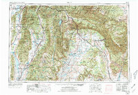
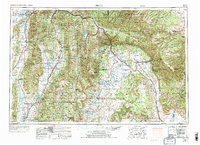
1956 Map of Price
USGS Topo · Published 1968About this map
Central Utah's high desert and mountain basins reveal a landscape of industrial extraction and agricultural irrigation in the mid-1950s. The concentration of settlements along the San Pitch Mountains and Wasatch Plateau reflects the vital role of water management, evidenced by numerous catchments like the Sevier Bridge Reservoir and Gunnison Reservoir. The eastern portion of the map is dominated by the dramatic geological formations of the Book Cliffs and Roan Cliffs, where the Geneva Coal Mine highlights the region's historical reliance on coal production. Transport networks are anchored by the Union Pacific and the Denver and Rio Grande Western railroads, which facilitated the movement of resources through steep canyons and across the Swell. Small agricultural hubs such as Manti, Ephraim, and Mount Pleasant contrast with the rugged terrain of the surrounding Manti La Sal National Forest.
Find a feature on this map
81 named features on this map. Tap any name to fly to it.
Don’t see what you’re looking for? This feature index may not catch every label — zoom into the map to look around manually.
Map Details
Editions of this 1956 Price Map
3 editions found
Other maps of this area

1885 · San Rafael
USGS Topo · 1:250,000

1885 · Salt Lake
USGS Topo · 1:250,000

1885 · Manti
USGS Topo · 1:250,000

1885 · East Tavaputs
USGS Topo · 1:250,000

1885 · La Sal
USGS Topo · 1:250,000

1885 · Beaver
USGS Topo · 1:250,000

1885 · Ashley
USGS Topo · 1:250,000

1885 · Sevier Desert
USGS Topo · 1:250,000

1885 · Fish Lake
USGS Topo · 1:250,000

1885 · Uinta
USGS Topo · 1:250,000