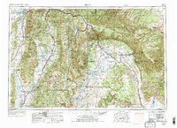
1956 Map of Price
USGS Topo · Published 1973About this map
The Sanpete Valley and Castle Valley anchor this mid-century portrait of Central Utah, where high-mountain forests meet the sprawling desert plateaus. The agricultural lifeblood of the western side is traced through the San Pitch River and Sevier River, supporting established settlements like Manti, Ephraim, and Mount Pleasant. To the east, the industrial character of the region emerges with the Sunnyside Coal Mine and the specialized transport networks of the Utah Railway and Denver and Rio Grande Western railroads.
Find a feature on this map
170 named features on this map. Tap any name to fly to it.
Don’t see what you’re looking for? This feature index may not catch every label — zoom into the map to look around manually.
Map Details
Editions of this 1956 Price Map
3 editions found

Other maps of this area

1885 · San Rafael
USGS Topo · 1:250,000

1885 · Salt Lake
USGS Topo · 1:250,000

1885 · Manti
USGS Topo · 1:250,000

1885 · East Tavaputs
USGS Topo · 1:250,000

1885 · La Sal
USGS Topo · 1:250,000

1885 · Beaver
USGS Topo · 1:250,000

1885 · Ashley
USGS Topo · 1:250,000

1885 · Sevier Desert
USGS Topo · 1:250,000

1885 · Fish Lake
USGS Topo · 1:250,000

1885 · Uinta
USGS Topo · 1:250,000