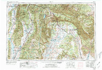
1956 Map of Price
USGS Topo · Published 1973About this map
Juab Valley and Sanpete Valley anchor the western reaches of this mid-century survey, where Mormon corridor settlements like Manti, Ephraim, and Mount Pleasant line the base of the high plateaus. The landscape transitions sharply eastward into the industrial and transit corridors of the Price River drainage, where the Denver and Rio Grande Western RR winds through steep canyons toward Price and the mining districts. This era shows the critical infrastructure of the high desert, from the waters of Scofield Reservoir and Gunnison Reservoir to the irrigation networks of the Highland Canal. Between the irrigated valleys and the Uintah and Ouray Reservation to the northeast, the map details a complex network of rail stations like Kyune Station and Nolan Station that once served as vital links in the region’s coal and freight economy.
Find a feature on this map
188 named features on this map. Tap any name to fly to it.
Don’t see what you’re looking for? This feature index may not catch every label — zoom into the map to look around manually.
Map Details
Editions of this 1956 Price Map
3 editions found

Other maps of this area

1885 · San Rafael
USGS Topo · 1:250,000

1885 · Salt Lake
USGS Topo · 1:250,000

1885 · Manti
USGS Topo · 1:250,000

1885 · East Tavaputs
USGS Topo · 1:250,000

1885 · La Sal
USGS Topo · 1:250,000

1885 · Beaver
USGS Topo · 1:250,000

1885 · Ashley
USGS Topo · 1:250,000

1885 · Sevier Desert
USGS Topo · 1:250,000

1885 · Fish Lake
USGS Topo · 1:250,000

1885 · Uinta
USGS Topo · 1:250,000