1970s Maps of Summit County, Utah
Explore 14 historic maps of Summit County from the 1970s. These maps offer a rare glimpse into what life looked like during the 1970s — showing old roads, neighborhoods, homes, and landmarks that have changed or disappeared over time.
Whether you're researching your family's past, planning a metal detecting trip, or studying how Summit County's landscape evolved across the 1970s, these high-resolution maps are a powerful tool for exploring the history of this region.
- Focus on a specific era: All maps on this page are from the 1970s, giving you a focused view of this time period.
- See what’s changed: Compare century-old streets, trails, and buildings to today's modern landscape using overlays and satellite layers.
- Research with precision: Use these maps for genealogy, historical research, land use analysis, or educational projects.
- View, download, or print: Maps are fully viewable online in high resolution, and can be downloaded or printed for your own records.
Start exploring Summit County's history through authentic maps from the 1970s. This is your window into the past.
Summit County, UT maps
(14)- 1972 Map of Iron Mine Mountain, 1974 Print
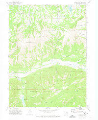
 1972 Iron Mine Mountain1974 Print · USGSThe high Uinta wilderness in the early seventies shows a landscape where historic treaty lines meet modern water engineering. Trace the path of the Duchesne Tunnel or locate remote camps like Cobblerest Campground and Iron Mine Campground.
 - 1972 Map of Seven Tree Flat, 1974 Print
 1972 Seven Tree Flat1974 Print · USGSHigh in the Uinta Mountains in the early seventies, this survey captures the remote headwaters and forest lands of the Utah-Wyoming border. Researchers can trace the courses of the West Fork Bear River and Chalk Creek or navigate the Jeep Trails around Seven Tree Flat.2 unique versions available
 - 1972 Map of Erickson Basin, 1974 Print
 1972 Erickson Basin1974 Print · USGSThe high alpine country of the Wasatch Range is captured here in the early seventies, detailing a landscape of glacial basins and mountain lakes. Trace the paths of the Smith Morehouse Trail (Pack) past Rhoads Lake and the Ledgefork Guard Sta.
 - 1972 Map of Soapstone Basin, 1974 Print
 1972 Soapstone Basin1974 Print · USGSThe high Uinta backcountry in the early 1970s was a hub for forest management and mountain recreation. Trace the early layout of Camp Roger, the Soapstone Guard Sta, and remote camps like Piuta Camp along the river forks.2 unique versions available
 - 1972 Map of Mirror Lake, 1974 Print
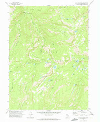
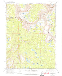
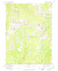 1972 Mirror Lake1974 Print · USGSThe High Uintas wilderness is captured here in the early seventies, showing a landscape of alpine lakes and forest service outposts. Genealogists and hikers can trace historic routes like the Smith Morehouse Trail or locate old sites like Camp Steiner and the Mirror Lake Guard Sta.2 unique versions available
 - 1972 Map of Deadman Mountain, 1974 Print
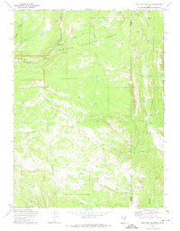
 1972 Deadman Mountain1974 Print · USGSThe high Uinta wilderness in the early seventies showcases a landscape of alpine ranching and complex irrigation canals. Researchers can trace the routes of the Hilliard Canal, find the Burts-Miller Ranch, or locate the Hill Air Force Base Recreation Camp.2 unique versions available
 - 1972 Map of Hoyt Peak, 1974 Print
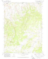
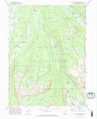
 1972 Hoyt Peak1974 Print · USGSThe high Wasatch backcountry in the early seventies shows a wilderness of alpine lakes and timber flats before modern development. Genealogists and hikers can trace old routes like the Pack Trail or locate landmarks such as Samak and Shingle Mill Flat.3 unique versions available
 - 1972 Map of Red Hole, 1974 Print
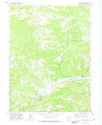
 1972 Red Hole1974 Print · USGSThe high timber and ranchlands of the Utah-Wyoming border are captured here in the early seventies as the region supported remote sheep and cattle operations. Researchers can locate family-named landmarks like Rigby Ranch and Anzard Ranch or trace the trails near Joyce Lake.
 - 1972 Map of Hayden Peak, 1974 Print
 1972 Hayden Peak1974 Print · USGSThe high Uintas in the early seventies appear here as a pristine wilderness of glacial basins and treaty lines. Trace the historic Indian Treaty Boundary and the paths of early travelers along the Highline Trail near Hayden Pass.2 unique versions available
 - 1972 Map of Christmas Meadows, 1974 Print
 1972 Christmas Meadows1974 Print · USGSThe high Uinta wilderness comes into focus during the early 1970s, showing the primitive road and trail networks of the Wasatch National Forest. You can trace the rugged approaches to Lamotte Peak or locate established recreational sites like Christmas Meadows Campground and Stillwater Campground.2 unique versions available
 - 1972 Map of Hidden Lake, 1974 Print
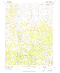
 1972 Hidden Lake1974 Print · USGSSummit County high country in the early seventies is mapped here with focus on the headwaters and forest management. Genealogists and hikers can trace the paths of South Fork Chalk Creek or locate landmarks like Shingle Mill Lake and Whites Basin.3 unique versions available
 - 1972 Map of Whitney Reservoir, 1974 Print
 1972 Whitney Reservoir1974 Print · USGSHigh in the Uinta Mountains during the early seventies, this area shows a landscape of forest management and alpine hydrology. Trace the remote network of trails and water systems connecting the Whitney Guard Sta, Whitney Reservoir, and high-country landmarks like Bourbon Lake.3 unique versions available
 - 1972 Map of Slader Basin, 1974 Print
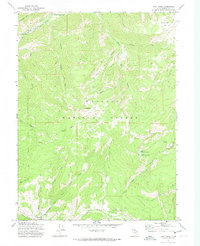
 1972 Slader Basin1974 Print · USGSHigh in the Wasatch Mountains during the early seventies, this area reveals a landscape of ranching and high-country recreation. Map enthusiasts can trace the Weber River headwaters and locate remote landmarks like Thousand Peaks Ranch and the Smith and Morehouse Reservoir.2 unique versions available
 - 1972 Map of Woodland, 1974 Print
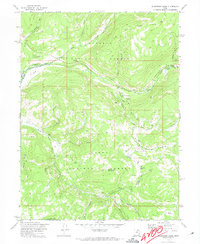
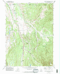
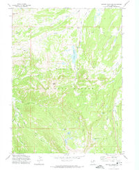
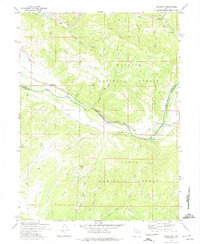 1972 Woodland1974 Print · USGSThe Provo River valley in the early 1970s is shown here at the meeting point of the Wasatch and Uinta national forests. Researchers can locate the local Cemetery, trace high-country Pack Trails, and identify sites like the Fish Hatchery and Oakcrest Camp.3 unique versions available
End of results
Showing maps 1-14 of 14
Top cities of Summit County
- Park City historical maps
- Snyderville historical maps
- Kamas historical maps
- Coalville historical maps
- Oakley historical maps
- Francis historical maps
See more
Frequently asked questions
- What are the different types of historical maps available for Summit County?
- What is the oldest map of Summit County?
- Where can I purchase historical maps of Summit County for my home or office?
- Where can I download high-res historical maps of Summit County?
- Are there historical topographic maps available for Summit County?
- Is there historical aerial imagery available for Summit County?
- Where are historical maps of Summit County sourced from?