1990s Maps of Summit County, Utah
Explore 55 historic maps of Summit County from the 1990s. These maps offer a rare glimpse into what life looked like during the 1990s — showing old roads, neighborhoods, homes, and landmarks that have changed or disappeared over time.
Whether you're researching your family's past, planning a metal detecting trip, or studying how Summit County's landscape evolved across the 1990s, these high-resolution maps are a powerful tool for exploring the history of this region.
- Focus on a specific era: All maps on this page are from the 1990s, giving you a focused view of this time period.
- See what’s changed: Compare century-old streets, trails, and buildings to today's modern landscape using overlays and satellite layers.
- Research with precision: Use these maps for genealogy, historical research, land use analysis, or educational projects.
- View, download, or print: Maps are fully viewable online in high resolution, and can be downloaded or printed for your own records.
Start exploring Summit County's history through authentic maps from the 1990s. This is your window into the past.
Summit County, UT maps
(55)- 1991 Map of Henefer
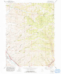 1991 Henefer1991 Print · USGSHenefer and its surrounding river valley are captured in the early nineties, showing a landscape defined by the Weber River and the rugged canyons of Summit County. Local historians can locate the Pioneer Monument, numerous claypits, and remote points like China Town and Windy Knoll.
 - 1991 Map of Castle Rock
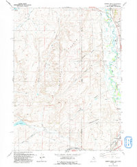
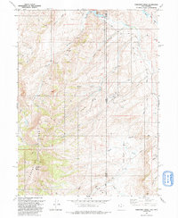
 1991 Castle Rock1991 Print · USGSSummit County ranching and energy development are captured here in the early nineties near the Wyoming border. Researchers can trace the layout of Castle Rock and locate scattered Oil Well sites and remote landmarks like Cache Cave Creek.
 - 1991 Map of Devils Slide
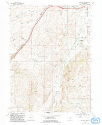
 1991 Devils Slide1991 Print · USGSUpper Weber Canyon and Henefer Valley appear in the early 1990s as a vital transportation and industrial corridor. Local researchers can trace the Mormon Pioneers route alongside the Union Pacific and landmarks like the Devils Slide and the Cement Plant.
 - 1991 Map of Wahsatch
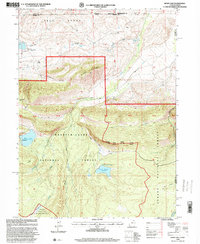
 1991 Wahsatch1991 Print · USGSThe high mountain passes of the Utah-Wyoming border were still defined by historic transit routes and energy infrastructure in the early nineties. Genealogists and historians can trace the EMIGRANT TRAIL past The Needles and the old settlement at Wahsatch.
 - 1991 Map of Murphy Ridge
 1991 Murphy Ridge1991 Print · USGSRich County, Utah, and the Wyoming borderlands are captured here in the early nineties, showing a landscape of high-altitude ranching and energy extraction. Genealogists and researchers can trace the settlement at Almy, locate the Almy Cem, and follow the winding Bear River through this complex border terrain.
 - 1991 Map of Francis Canyon
 1991 Francis Canyon1991 Print · USGSThe high mountain country of Morgan County is documented here in the early nineties at the intersection of the Rich and Summit county lines. Researchers can trace historic grazing routes and water sources through Doc Dorlands Hollow, Gilberts Pond, and the Lost Creek Reservoir.
 - 1991 Map of Shearing Corral
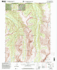
 1991 Shearing Corral1991 Print · USGSThe high ridges of Rich County are captured here in the early 1990s, showing a landscape of livestock ranching and water management. Genealogists and local historians can trace family-named landmarks like Suttons Reservoir, Heiners Springs, and the historic Cache Cave.
 - 1991 Map of Heiners Creek
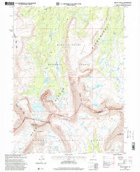
 1991 Heiners Creek1991 Print · USGSSummit County's high-country terrain is captured here in the early nineties, centered on the vital corridor of Echo Canyon. Researchers can trace the paths of Heiners Creek and Grass Valley Creek alongside local landmarks like Spring Emory.
 - 1991 Map of Mirror Lake
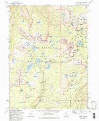 1991 Mirror Lake1991 Print · USGSThe high Uintas in the early 1970s reveal a landscape of alpine lakes and early forest service outposts. You can trace the historic Indian Treaty Boundary and locate backcountry landmarks like the Mirror Lake Guard Sta and Notch Mountain.
 - 1991 Map of Porcupine Ridge
 1991 Porcupine Ridge1991 Print · USGSThe high borderlands of Summit County and Wyoming are captured here in the early nineties, revealing a landscape defined by energy exploration. You can trace the development of the local Oil Field and find specific landmarks like the Barker Reservoir, Porcupine Mtn, and numerous Oil Wells.
 - 1996 Map of Chepeta Lake, 1999 Print
 1996 Chepeta Lake1999 Print · USGSThe high basins of the Uintas are captured here during the late twentieth century, showing where three northern Utah counties converge. Hikers and researchers can trace remote alpine routes through North Pole Pass to landmarks like Spirit Lake Lodge and Chepeta.
 - 1996 Map of Mount Lovenia, 1999 Print
 1996 Mount Lovenia1999 Print · USGSThe High Uintas at the end of the twentieth century show a remote landscape of intersecting national forests and alpine peaks. Researchers can trace the high-altitude divide at Mount Lovenia and Squaw Pass or follow the glacial headwaters of the Middle Fork Blacks Fork.
 - 1996 Map of Fox Lake, 1999 Print
 1996 Fox Lake1999 Print · USGSThe High Uintas backcountry in the 1990s reveals a high-altitude wilderness of alpine lakes and mountain passes. Trace remote routes through Corral Meadows, cross the Shale Creek Bridge, and navigate the terrain around Thompson Peak.
 - 1996 Map of Kings Peak, 1999 Print
 1996 Kings Peak1999 Print · USGSThe High Uintas were a strictly managed wilderness in the late nineties, centered on the state's highest summits. Hikers and historians can trace the routes through Gunsight Pass or locate alpine landmarks like Kings Peak and Lake George Beard.
 - 1996 Map of Hayden Peak, 2000 Print
 1996 Hayden Peak2000 Print · USGSThe High Uintas were a pristine wilderness frontier in the mid-1990s, where three national forests meet at the county divide. Hikers and historians can trace high-altitude routes like the Highline Trail and name dozens of alpine waters from Kamas Lake to Amethyst Lake.
 - 1996 Map of Iron Mine Mountain, 2000 Print
 1996 Iron Mine Mountain2000 Print · USGSThe high Uinta backcountry is captured here in the mid-1990s at the intersection of three national forests. Outdoor historians and researchers can trace the industrial legacy of the Iron Mine or locate early water projects like the Duchesne Tunnel and Spruce Springs Reservoir.
 - 1996 Map of Hoop Lake, 2000 Print
 1996 Hoop Lake2000 Print · USGSHigh-altitude borderlands in the Uintas appear here in the mid-nineties as the wilderness and forest boundaries meet. Researchers can trace remote resource infrastructure like the Landing Strip at Gregory Basin and the spillway at Hoop Lake.
 - 1996 Map of Red Knob, 2000 Print
 1996 Red Knob2000 Print · USGSThe High Uintas during the late 1990s showcase a high-altitude landscape of remote peaks and glacial lakes. Researchers can trace historic pass routes such as Deadman Pass or locate alpine landmarks like The Cathedral and the meadows of Buck Pasture.
 - 1996 Map of Explorer Peak, 2000 Print
 1996 Explorer Peak2000 Print · USGSThe High Uintas wilderness at the turn of the millennium was an alpine expanse of remote peaks and glacial tarns. Trace high-altitude routes along the High Line Trail and through Dead Horse Pass, or locate landmarks like Explorer Peak and Jack and Jill Lakes.
 - 1996 Map of Mount Powell, 2000 Print
 1996 Mount Powell2000 Print · USGSThe high Uinta peaks in the mid-1990s are mapped here in their primitive state, showing the divide between the north and south slopes. Researchers can trace remote alpine trails over Smiths Fork Pass and Anderson Pass or locate the dramatic cliffs of Red Castle.
 - 1997 Map of Devils Slide, 2001 Print
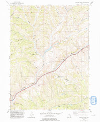
 1997 Devils Slide2001 Print · USGSThe Morgan and Summit county border area in the late nineties shows a landscape of industrial limestone extraction and river-corridor settlement. Genealogists and local historians can trace the Mormon Pioneers route or locate landmarks in Henefer and Croydon.
 - 1997 Map of Turner Hollow, 2001 Print
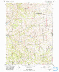
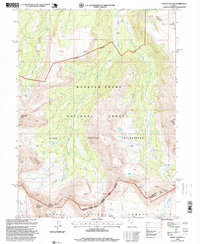
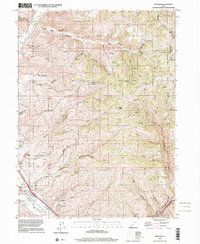
 1997 Turner Hollow2001 Print · USGSSummit County's rugged mining and energy landscape is captured here in the late twentieth century. Researchers can locate the Grass Creek (Site) and trace the industrial legacy of the Weber Mine and Chappell Mine along the canyon floors.
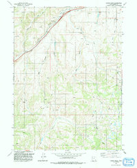
 - 1997 Map of Wanship, 2001 Print
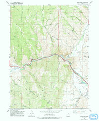
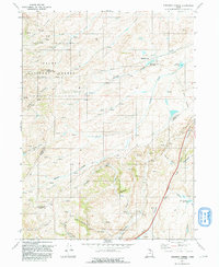
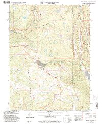
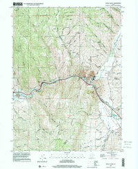
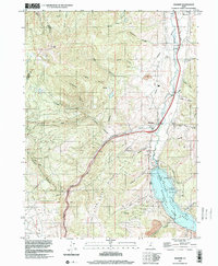 1997 Wanship2001 Print · USGSThe Weber River valley in the late 1990s is defined by the intersection of mountain transit and the waters of Rockport Lake. Researchers can trace the Union Pacific Railroad through Wanship or locate rural Cem sites and Gravel Pits near Hoytsville.
 - 1997 Map of Coalville, 2001 Print
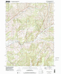
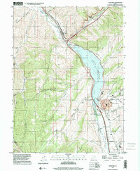 1997 Coalville2001 Print · USGSThe Weber River valley in the late nineties shows a landscape defined by water management and transit. Trace the shoreline of Echo Reservoir and locate historic markers in Coalville, from the Rodeo Grounds to the Cem.
 - 1997 Map of Henefer, 2001 Print
 1997 Henefer2001 Print · USGSThe Morgan and Summit county lines meet near the settlement of Henefer in the late 1990s as the river valley supports both ranching and industry. Trace the local landscape through the Pioneer Monument, old Claypits, and the remote northern canyon at China Town.
Showing maps 1-25 of 55
Top cities of Summit County
- Park City historical maps
- Snyderville historical maps
- Kamas historical maps
- Coalville historical maps
- Oakley historical maps
- Francis historical maps
See more
Frequently asked questions
- What are the different types of historical maps available for Summit County?
- What is the oldest map of Summit County?
- Where can I purchase historical maps of Summit County for my home or office?
- Where can I download high-res historical maps of Summit County?
- Are there historical topographic maps available for Summit County?
- Is there historical aerial imagery available for Summit County?
- Where are historical maps of Summit County sourced from?