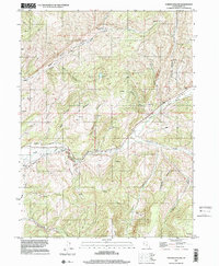
1997 Map of Turner Hollow
USGS Topo · Published 2001About this map
The Grass Creek Valley defines the northern reaches of this Summit County landscape, where the Grass Creek (Site) remains as a marker of earlier settlement. Resource extraction is a central theme of this terrain, evidenced by the Weber Mine and Chappell Mine, alongside modern energy infrastructure like the Compressor Station and Gas Storage Wells. The drainage patterns are dictated by the deep incisions of Chalk Creek and its South Fork, which carve through the high plateaus. Agricultural and water management efforts are visible through the North Narrows Ditch, which follows the contours of the Chalk Creek canyon. To the south, the terrain rises toward the Elkhorn Divide, separating the complex canyon systems of Cottonwood Canyon and Deer Pen Canyon from the meadows and hollows that characterize the central portion of the quadrangle.
Find a feature on this map
30 named features on this map. Tap any name to fly to it.
Don’t see what you’re looking for? This feature index may not catch every label — zoom into the map to look around manually.
Map Details
Editions of this 1997 Turner Hollow Map
This is the sole edition of this map. No revisions or reprints were ever made.
Other maps of this area

1885 · Salt Lake
USGS Topo · 1:250,000

1900 · Coalville
USGS Topo · 1:125,000

1903 · Coalville
USGS Topo · 1:125,000

1954 · Salt Lake City
USGS Topo · 1:250,000

1954 · Ogden
USGS Topo · 1:250,000

1958 · Ogden
USGS Topo · 1:250,000

1958 · Salt Lake City
USGS Topo · 1:250,000

1960 · Ogden
USGS Topo · 1:250,000

1960 · Salt Lake City
USGS Topo · 1:250,000
1964 · Henefer
USGS Topo · 1:24,000