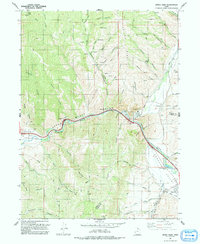
1991 Map of Devils Slide
USGS Topo · Published 1991About this map
Upper Weber Canyon and the Henefer Valley dominate this northern Utah landscape, where the Weber River carves through steep terrain. The geological landmark Devils Slide is a central focal point, situated near industrial developments including a large Cement Plant and the Union Pacific railroad corridor. This transit-heavy corridor also traces the historical path of the Mormon Pioneers, showing the enduring importance of this natural pass. Settlements like Henefer and Croydon are detailed with their local infrastructure, from the Cem near Croydon to the Rodeo Ground Park and Sewage Disposal Ponds in Henefer. The surrounding heights of Folley Ridge and Bolly Knob are dissected by numerous canyons and hollows, such as Coyote Hollow and Cottonwood Creek, illustrating a landscape shaped by both water and resource extraction as evidenced by various Mine and Quarry labels.
Find a feature on this map
57 named features on this map. Tap any name to fly to it.
Don’t see what you’re looking for? This feature index may not catch every label — zoom into the map to look around manually.
Map Details
Editions of this 1991 Devils Slide Map
This is the sole edition of this map. No revisions or reprints were ever made.
Other maps of this area

1885 · Salt Lake
USGS Topo · 1:250,000

1900 · Coalville
USGS Topo · 1:125,000

1903 · Coalville
USGS Topo · 1:125,000

1925 · Ft. Douglas
USGS Topo · 1:125,000

1928 · Ft. Douglas
USGS Topo · 1:125,000

1954 · Salt Lake City
USGS Topo · 1:250,000

1954 · Ogden
USGS Topo · 1:250,000

1958 · Ogden
USGS Topo · 1:250,000

1958 · Salt Lake City
USGS Topo · 1:250,000

1960 · Ogden
USGS Topo · 1:250,000