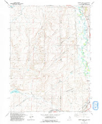
1991 Map of Murphy Ridge
USGS Topo · Published 1991About this map
The Bear River winds along the border of Utah and Wyoming, anchoring a landscape defined by high ridges and irrigation engineering. On the eastern edge, the settlement of Almy is situated near the Almy Cem, providing a focal point for genealogical research in this borderland. The topography is dominated by the massive Murphy Ridge, which is flanked by numerous drainage basins including Stacey Hollow, Bartlett Hollow, and Thomas Canyon. This 1991 revision, based on earlier mid-century aerial photography, shows the significant role of water management in the region through features like the Chapman Canal, Neponset Reservoir, and Crane Reservoir. Transportation and utility infrastructure are also evident, from the City-County Airport (Burns Field) near the southern boundary to the complex network of 4WD trails and pipelines that service remote Oil Wells and ranching Corrals scattered across the high desert terrain.
Find a feature on this map
36 named features on this map. Tap any name to fly to it.
Don’t see what you’re looking for? This feature index may not catch every label — zoom into the map to look around manually.
Map Details
Editions of this 1991 Murphy Ridge Map
This is the sole edition of this map. No revisions or reprints were ever made.
Other maps of this area

1954 · Ogden
USGS Topo · 1:250,000

1958 · Ogden
USGS Topo · 1:250,000

1960 · Ogden
USGS Topo · 1:250,000

1965 · Evanston
USGS Topo · 1:24,000

1965 · Three Forks
USGS Topo · 1:24,000

1965 · Millis
USGS Topo · 1:24,000

1968 · Wahsatch
USGS Topo · 1:24,000

1968 · Shearing Corral
USGS Topo · 1:24,000

1968 · Mc Kay Hollow
USGS Topo · 1:24,000

1968 · Neponset Reservoir NE
USGS Topo · 1:24,000