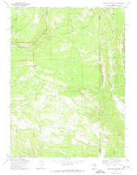
1972 Map of Iron Mine Mountain
USGS Topo · Published 1974About this map
Iron Mine Mountain stands at the center of this high-elevation landscape, where the administrative boundaries of three national forests—Uinta, Ashley, and Wasatch—converge. This 1972 survey captures a wilderness dominated by hydrological engineering and recreation. The Duchesne Tunnel cuts through the subterranean terrain, connecting water systems near the Provo River and Smooth Rock Falls.
Find a feature on this map
40 named features on this map. Tap any name to fly to it.
Don’t see what you’re looking for? This feature index may not catch every label — zoom into the map to look around manually.
Map Details
Editions of this 1972 Iron Mine Mountain Map
This is the sole edition of this map. No revisions or reprints were ever made.
Other maps of this area

1885 · Salt Lake
USGS Topo · 1:250,000

1885 · Uinta
USGS Topo · 1:250,000

1900 · Coalville
USGS Topo · 1:125,000

1901 · Hayden Peak
USGS Topo · 1:125,000

1903 · Hayden Peak
USGS Topo · 1:125,000

1903 · Coalville
USGS Topo · 1:125,000

1907 · Strawberry Valley
USGS Topo · 1:125,000

1909 · Strawberry Valley
USGS Topo · 1:125,000

1954 · Salt Lake City
USGS Topo · 1:250,000

1958 · Salt Lake City
USGS Topo · 1:250,000