1990s Maps of Jeremy Ranch, Utah
Explore 1 historic maps of Jeremy Ranch from the 1990s. These maps offer a rare glimpse into what life looked like during the 1990s — showing old roads, neighborhoods, homes, and landmarks that have changed or disappeared over time.
Whether you're researching your family's past, planning a metal detecting trip, or studying how Jeremy Ranch's landscape evolved across the 1990s, these high-resolution maps are a powerful tool for exploring the history of this region.
- Focus on a specific era: All maps on this page are from the 1990s, giving you a focused view of this time period.
- See what’s changed: Compare century-old streets, trails, and buildings to today's modern landscape using overlays and satellite layers.
- Research with precision: Use these maps for genealogy, historical research, land use analysis, or educational projects.
- View, download, or print: Maps are fully viewable online in high resolution, and can be downloaded or printed for your own records.
Start exploring Jeremy Ranch's history through authentic maps from the 1990s. This is your window into the past.
Jeremy Ranch, UT maps
(1)- 1998 Map of Big Dutch Hollow, 2000 Print
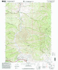 1998 Big Dutch Hollow2000 Print · USGSThe Mormon migration and Pony Express trails meet modern developments in these Utah mountains during the late nineties. Trace the Mormon Pioneers Route past Mormon Flat and the historic Macfarlane Ranch.
End of results
Showing maps 1-1 of 1
Top cities near Jeremy Ranch
- Salt Lake City historical maps
- Sandy historical maps
- Millcreek historical maps
- Draper historical maps
- Cottonwood Heights historical maps
- Park City historical maps
See more
Frequently asked questions
- What are the different types of historical maps available for Jeremy Ranch?
- What is the oldest map of Jeremy Ranch?
- Where can I purchase historical maps of Jeremy Ranch for my home or office?
- Where can I download high-res historical maps of Jeremy Ranch?
- Are there historical topographic maps available for Jeremy Ranch?
- Is there historical aerial imagery available for Jeremy Ranch?
- Where are historical maps of Jeremy Ranch sourced from?