1960s Maps of Tridell, Utah
Explore 2 historic maps of Tridell from the 1960s. These maps offer a rare glimpse into what life looked like during the 1960s — showing old roads, neighborhoods, homes, and landmarks that have changed or disappeared over time.
Whether you're researching your family's past, planning a metal detecting trip, or studying how Tridell's landscape evolved across the 1960s, these high-resolution maps are a powerful tool for exploring the history of this region.
- Focus on a specific era: All maps on this page are from the 1960s, giving you a focused view of this time period.
- See what’s changed: Compare century-old streets, trails, and buildings to today's modern landscape using overlays and satellite layers.
- Research with precision: Use these maps for genealogy, historical research, land use analysis, or educational projects.
- View, download, or print: Maps are fully viewable online in high resolution, and can be downloaded or printed for your own records.
Start exploring Tridell's history through authentic maps from the 1960s. This is your window into the past.
Tridell, UT maps
(2)- 1960 Map of Vernal
 1960 Vernal1960 Print · USGSNortheastern Utah was a rugged frontier of mineral extraction and federal conservation in the mid-twentieth century. Genealogists and historians can trace the growth of Vernal, locate Gilsonite mining operations near Bonanza, and explore the 1950s boundaries of Dinosaur National Monument.
 - 1964 Map of Lapoint, 1965 Print
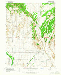 1964 Lapoint1965 Print · USGSUintah County land and water rights take center stage in the mid-1960s within the Uintah and Ouray Indian Reservation. Researchers can trace irrigation networks like the Deep Creek Canal and find family sites near Tridell or the Lapoint Cemetery.2 unique versions available
End of results
Showing maps 1-2 of 2
Top cities near Tridell
Frequently asked questions
- What are the different types of historical maps available for Tridell?
- What is the oldest map of Tridell?
- Where can I purchase historical maps of Tridell for my home or office?
- Where can I download high-res historical maps of Tridell?
- Are there historical topographic maps available for Tridell?
- Is there historical aerial imagery available for Tridell?
- Where are historical maps of Tridell sourced from?