Old Maps of West Portal, Utah for Hiking & Exploration
Hike through history with 15 historic maps of West Portal. Explore old trails, ghost towns, and forgotten backroads — perfect for outdoor adventurers and local explorers.
- Rediscover forgotten places: Map out old mining camps, roads, and footpaths that no longer exist on modern maps.
- Layer with modern tools: Combine with LiDAR or satellite views to plan hikes through historical terrain.
- Made for exploration: Popular among hikers, overlanders, and local history lovers.
Use these maps to find adventure and explore the hidden past of West Portal.
West Portal, UT maps
(15)- 1885 Map of Salt Lake
 1885 Salt Lake1885 Print · USGSThe Wasatch Front and surrounding high valleys appear here in the mid-1880s during a period of rapid mining and rail expansion. Genealogists and historians can trace early town sites and mining camps including Alta, Silver City, and the military grounds of Fort Douglass.7 unique versions available
 - 1907 Map of Strawberry Valley, 1955 Print
 1907 Strawberry Valley1955 Print · USGSIn the early 1900s, this high-mountain territory was defined by the ranching and rail connections of the Uinta region. Researchers can trace family-named outposts like Averetts Ranch, the Diamond Battle Monument, and the early route of the D and R G RR.2 unique versions available
 - 1909 Map of Strawberry Valley
 1909 Strawberry Valley1909 Print · USGSWasatch County at the dawn of the twentieth century shows a landscape of mountain ranches and early settlements before the major dams. Genealogists and historians can trace family locations at Averetts Ranch, locate the Diamond Battle Monument, and follow the old D and R G RR line.2 unique versions available
 - 1954 Map of Salt Lake City, 1964 Print
 1954 Salt Lake City1964 Print · USGSThe Wasatch Front and Uinta Mountains are captured here in the mid-fifties, showing the industrial heart of Utah and its high mountain wilderness. Researchers can locate vanished infrastructure and landmarks like the Geneva Steel Plant, Bingham Canyon Mine, and the Utah State Prison.4 unique versions available
 - 1958 Map of Salt Lake City
 1958 Salt Lake City1958 Print · USGSThe Wasatch Front and Uinta Basin are captured during a period of significant post-war growth and industrial development. Researchers can trace the mid-century rail lines of the Bamberger RR and locate sites like the Kiegley Limestone Quarry and Camp Williams Military Reservation.
 - 1960 Map of Salt Lake City
 1960 Salt Lake City1960 Print · USGSThe Wasatch Front and High Uintas are captured mid-century as the Salt Lake Valley underwent significant postwar expansion. Genealogists and historians can trace rail lines like the Union Pacific and locate established landmarks such as Fort Douglas, Camp Williams, and the Bingham Canyon Mine.
 - 1967 Map of Two Tom Hill, 1969 Print
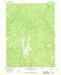 1967 Two Tom Hill1969 Print · USGSThe high backcountry of the Wasatch Range is captured here in the late sixties, highlighting the intersection of forest management and early recreation. Researchers can locate the Diamond Fork Guard Station, trace the INDIAN TREATY BOUNDARY, and find remote sites like Springville Crossings.2 unique versions available
 - 1986 Map of Provo
 1986 Provo1986 Print · USGSThe Utah Valley during the mid-eighties shows a bustling corridor of growth between the mountains and Utah Lake. Genealogists and historians can trace the rail lines of the Union Pacific RR through settlements like Springville, Spanish Fork, and Payson.
 - 1993 Map of Two Tom Hill, 1994 Print
 1993 Two Tom Hill1994 Print · USGSThis high-country portion of the Wasatch and Utah county line shows the mountain landscape in the 1990s. Researchers can trace historic access routes via Pack Trails and locate remote landmarks like the Diamond Fork Guard Station and Mollies Nipple.
 - 1998 Map of Two Tom Hill, 2000 Print
 1998 Two Tom Hill2000 Print · USGSThe high canyons and timbered ridges of the Utah and Wasatch county lines are captured here in the late nineties. Researchers can locate remote forestry outposts like Diamond Fork Guard Station and distinctive landmarks including Mollies Nipple and Two Tom Hill.
 - 2011 Map of Two Tom Hill, 2011 Print
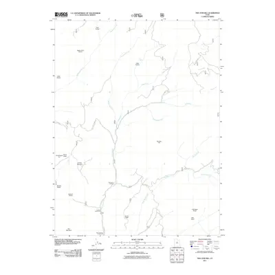 2011 Two Tom Hill2011 Print · USGSCovers West Portal, including Utah County, Wasatch County, and other nearby areas
 - 2014 Map of Two Tom Hill, 2014 Print
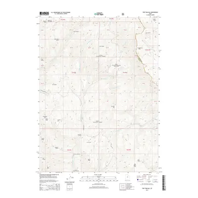 2014 Two Tom Hill2014 Print · USGSCovers West Portal, including Utah County, Wasatch County, and other nearby areas
 - 2017 Map of Two Tom Hill, 2017 Print
 2017 Two Tom Hill2017 Print · USGSCovers West Portal, including Utah County, Wasatch County, and other nearby areas
 - 2020 Map of Two Tom Hill, 2020 Print
 2020 Two Tom Hill2020 Print · USGSCovers West Portal, including Utah County, Wasatch County, and other nearby areas
 - 2023 Map of Two Tom Hill, 2023 Print
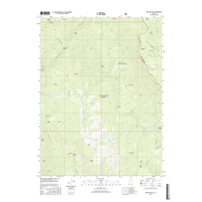
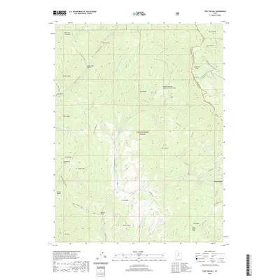
 2023 Two Tom Hill2023 Print · USGSThe high country of the Utah and Wasatch county line is captured here in the 2020s, showing a landscape defined by winter recreation and water management. Trace backcountry routes like Diamond Fork Rd and find landmarks such as West Portal and Mollies Nipple.
End of results
Showing maps 1-15 of 15
Top cities near West Portal
Frequently asked questions
- What are the different types of historical maps available for West Portal?
- What is the oldest map of West Portal?
- Where can I purchase historical maps of West Portal for my home or office?
- Where can I download high-res historical maps of West Portal?
- Are there historical topographic maps available for West Portal?
- Is there historical aerial imagery available for West Portal?
- Where are historical maps of West Portal sourced from?