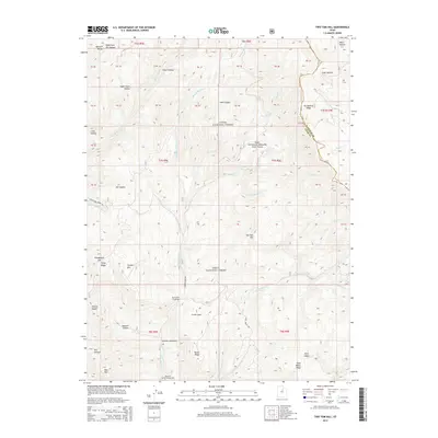
2014 Map of Two Tom Hill
USGS Topo · Published 2014About this map
Uinta National Forest dominates this landscape in the Wasatch Range, where the drainages of the Diamond Fork and Sixth Water Cr converge. The topography is defined by high ridgelines and deep canyons, including the prominent Strawberry Ridge along the border of Wasatch and Utah counties. Cultural markers are concentrated along the primary corridors of Diamond Fork Rd and Rays Valley Rd, which provide access to recreation sites like Hawthorn Campground and Mineral Spring Campground. The area includes several named peaks and slopes, most notably Two Tom Hill and the uniquely named Mollies Nipple. Within these canyons, historical land use is suggested by features such as Sawmill Hollow and Pumphouse Hill. The Ruby Christensen Memorial Youth Forest sits in the central-east portion of the sheet, while the small settlement of Springville Crossings marks a key junction in the canyon floor.
Find a feature on this map
61 named features on this map. Tap any name to fly to it.
Don’t see what you’re looking for? This feature index may not catch every label — zoom into the map to look around manually.
Map Details
Editions of this 2014 Two Tom Hill Map
This is the sole edition of this map. No revisions or reprints were ever made.
Other maps of this area

1885 · Salt Lake
USGS Topo · 1:250,000

1907 · Strawberry Valley
USGS Topo · 1:125,000

1909 · Strawberry Valley
USGS Topo · 1:125,000

1954 · Salt Lake City
USGS Topo · 1:250,000

1958 · Salt Lake City
USGS Topo · 1:250,000

1960 · Salt Lake City
USGS Topo · 1:250,000

1966 · Strawberry Reservoir NW
USGS Topo · 1:24,000
1966 · Strawberry Reservoir SW
USGS Topo · 1:24,000

1967 · Two Tom Hill
USGS Topo · 1:24,000
1967 · Granger Mtn
USGS Topo · 1:24,000