
1966 Map of Strawberry Reservoir NW
USGS Topo · Published 1968About this map
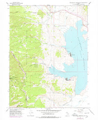
Strawberry Reservoir dominates the eastern half of this landscape, its waters reaching into the numerous canyons of the Uinta National Forest. The engineering of the early 20th-century reclamation project is visible through the Strawberry Tunnel, with both the West Portal and East Portal clearly marked, alongside the Diversion Canal designed to move water across the hydrographic divide. This area, managed by the Bryants Fork Guard Station, reveals a mix of early recreation and traditional land use.
Find a feature on this map
40 named features on this map. Tap any name to fly to it.
Don’t see what you’re looking for? This feature index may not catch every label — zoom into the map to look around manually.
Map Details
Editions of this 1966 Strawberry Reservoir NW Map
2 editions found
Other maps of this area

1885 · Salt Lake
USGS Topo · 1:250,000

1907 · Strawberry Valley
USGS Topo · 1:125,000

1909 · Strawberry Valley
USGS Topo · 1:125,000

1954 · Salt Lake City
USGS Topo · 1:250,000

1958 · Salt Lake City
USGS Topo · 1:250,000

1960 · Salt Lake City
USGS Topo · 1:250,000
1966 · Strawberry Reservoir NE
USGS Topo · 1:24,000
1966 · Strawberry Reservoir SW
USGS Topo · 1:24,000

1967 · Two Tom Hill
USGS Topo · 1:24,000
1967 · Co-Op Creek
USGS Topo · 1:24,000