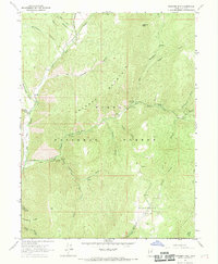
1967 Map of Granger Mtn
USGS Topo · Published 1969About this map
Uinta National Forest dominates this landscape, characterized by a complex network of canyons and high ridges east of the Utah Valley in the late 1960s. The map centers on the prominent Granger Mountain, surrounded by deeply incised drainages such as Whittemore Canyon, Grindstone Canyon, and Wannrhodes Canyon. The drainage of Hobble Creek provides the primary corridor for human activity, with its Right Fork and Left Fork serving as focal points for recreational development. This era of forest management is evidenced by several established recreation sites including Balsam Campground and Kolob Campground, alongside the Hobble Cr Guard Sta. The transition from lower elevations to the high Wanrhodes Basin is connected by a system of primitive routes and trails, reflecting the area's use for both conservation and mountain access before modern paved infrastructure reached deep into these draws.
Find a feature on this map
37 named features on this map. Tap any name to fly to it.
Don’t see what you’re looking for? This feature index may not catch every label — zoom into the map to look around manually.
Map Details
Editions of this 1967 Granger Mtn Map
2 editions found
Other maps of this area

1885 · Salt Lake
USGS Topo · 1:250,000

1907 · Strawberry Valley
USGS Topo · 1:125,000

1909 · Strawberry Valley
USGS Topo · 1:125,000

1948 · Orem
USGS Topo · 1:62,500

1948 · Springville
USGS Topo · 1:24,000

1948 · Bridal Veil Falls
USGS Topo · 1:24,000

1949 · Provo
USGS Topo · 1:62,500

1949 · Spanish Fork Peak
USGS Topo · 1:24,000
1950 · Bridal Veil Falls
USGS Topo · 1:24,000
1950 · Springville
USGS Topo · 1:24,000