2000-2009 Maps of Enterprise, Utah
Explore 2 historic maps of Enterprise from 2000-2009. These maps offer a rare glimpse into what life looked like during the 2000s — showing old roads, neighborhoods, homes, and landmarks that have changed or disappeared over time.
Whether you're researching your family's past, planning a metal detecting trip, or studying how Enterprise's landscape evolved across the 2000s, these high-resolution maps are a powerful tool for exploring the history of this region.
- Focus on a specific era: All maps on this page are from the 2000s, giving you a focused view of this time period.
- See what’s changed: Compare century-old streets, trails, and buildings to today's modern landscape using overlays and satellite layers.
- Research with precision: Use these maps for genealogy, historical research, land use analysis, or educational projects.
- View, download, or print: Maps are fully viewable online in high resolution, and can be downloaded or printed for your own records.
Start exploring Enterprise's history through authentic maps from the 2000s. This is your window into the past.
Enterprise, UT maps
(2)- 2002 Map of Enterprise, 2005 Print
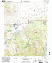 2002 Enterprise2005 Print · USGSEnterprise and the Escalante Valley are documented here in the early 2000s, showing the intersection of desert agriculture and high-country forest. Researchers can trace local heritage through landmarks like Winsor Mem Cem, Holt Cem, and the Enterprise High School.
 - 2002 Map of Hebron, 2005 Print
 2002 Hebron2005 Print · USGSThe area surrounding Hebron and the Dixie National Forest is shown here as it appeared at the turn of the millennium. Researchers can trace the layout of the Hebron Cem and examine the critical water systems of Lower Enterprise Reservoir and Upper Enterprise Reservoir.
End of results
Showing maps 1-2 of 2
Top cities near Enterprise
- Central historical maps
- Veyo historical maps
- Newcastle historical maps
- Pine Valley historical maps
- Beryl Junction historical maps
- Modena historical maps
Frequently asked questions
- What are the different types of historical maps available for Enterprise?
- What is the oldest map of Enterprise?
- Where can I purchase historical maps of Enterprise for my home or office?
- Where can I download high-res historical maps of Enterprise?
- Are there historical topographic maps available for Enterprise?
- Is there historical aerial imagery available for Enterprise?
- Where are historical maps of Enterprise sourced from?