1980s Maps of Bicknell, Utah
Explore 2 historic maps of Bicknell from the 1980s. These maps offer a rare glimpse into what life looked like during the 1980s — showing old roads, neighborhoods, homes, and landmarks that have changed or disappeared over time.
Whether you're researching your family's past, planning a metal detecting trip, or studying how Bicknell's landscape evolved across the 1980s, these high-resolution maps are a powerful tool for exploring the history of this region.
- Focus on a specific era: All maps on this page are from the 1980s, giving you a focused view of this time period.
- See what’s changed: Compare century-old streets, trails, and buildings to today's modern landscape using overlays and satellite layers.
- Research with precision: Use these maps for genealogy, historical research, land use analysis, or educational projects.
- View, download, or print: Maps are fully viewable online in high resolution, and can be downloaded or printed for your own records.
Start exploring Bicknell's history through authentic maps from the 1980s. This is your window into the past.
Bicknell, UT maps
(2)- 1980 Map of Loa
 1980 Loa1980 Print · USGSCentral Utah's high plateaus and the Fremont River corridor are captured here during the 1980s, showcasing a landscape of high-elevation reservoirs and remote ranching outposts. Genealogists can trace family names and early settlements from Loa and Teasdale to the orchards of Fruita.2 unique versions available
 - 1985 Map of Bicknell
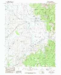 1985 Bicknell1985 Print · USGSWayne County ranching and water management are front and center in the mid-1980s as the town of Bicknell sits surrounded by the Fremont River and its wetlands. Genealogists and locals can trace family-named landmarks like Dab Keele Spring, Petes Pond, and Bullard Spring.
End of results
Showing maps 1-2 of 2
Top cities near Bicknell
Frequently asked questions
- What are the different types of historical maps available for Bicknell?
- What is the oldest map of Bicknell?
- Where can I purchase historical maps of Bicknell for my home or office?
- Where can I download high-res historical maps of Bicknell?
- Are there historical topographic maps available for Bicknell?
- Is there historical aerial imagery available for Bicknell?
- Where are historical maps of Bicknell sourced from?