1990s Maps of Leicester, Vermont
Explore 2 historic maps of Leicester from the 1990s. These maps offer a rare glimpse into what life looked like during the 1990s — showing old roads, neighborhoods, homes, and landmarks that have changed or disappeared over time.
Whether you're researching your family's past, planning a metal detecting trip, or studying how Leicester's landscape evolved across the 1990s, these high-resolution maps are a powerful tool for exploring the history of this region.
- Focus on a specific era: All maps on this page are from the 1990s, giving you a focused view of this time period.
- See what’s changed: Compare century-old streets, trails, and buildings to today's modern landscape using overlays and satellite layers.
- Research with precision: Use these maps for genealogy, historical research, land use analysis, or educational projects.
- View, download, or print: Maps are fully viewable online in high resolution, and can be downloaded or printed for your own records.
Start exploring Leicester's history through authentic maps from the 1990s. This is your window into the past.
Leicester, VT maps
(2)- 1997 Map of Brandon, 2000 Print
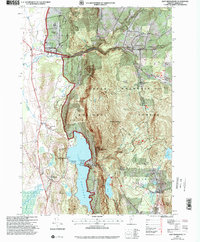
 1997 Brandon2000 Print · USGSRutland County in the late nineties shows a landscape where historic valley settlements meet the rising Green Mountains. Researchers can trace the legacy of local education and industry through the Brandon State School, numerous Quarry sites, and the Churchill House.
 - 1997 Map of East Middlebury, 2000 Print
 1997 East Middlebury2000 Print · USGSAddison County at the close of the twentieth century shows a landscape defined by the Green Mountains and literary heritage. Researchers can trace the boundaries of Ripton and Salisbury, locating family landmarks like Cooks Cem or the Plain Sch schoolhouse.
End of results
Showing maps 1-2 of 2
Top cities near Leicester
- Middlebury historical maps
- Brandon historical maps
- Fair Haven historical maps
- Warren historical maps
- Bristol historical maps
- West Rutland historical maps
See more
Top neighborhoods of Leicester
Frequently asked questions
- What are the different types of historical maps available for Leicester?
- What is the oldest map of Leicester?
- Where can I purchase historical maps of Leicester for my home or office?
- Where can I download high-res historical maps of Leicester?
- Are there historical topographic maps available for Leicester?
- Is there historical aerial imagery available for Leicester?
- Where are historical maps of Leicester sourced from?