1970s Maps of Essex County, Vermont
Explore 4 historic maps of Essex County from the 1970s. These maps offer a rare glimpse into what life looked like during the 1970s — showing old roads, neighborhoods, homes, and landmarks that have changed or disappeared over time.
Whether you're researching your family's past, planning a metal detecting trip, or studying how Essex County's landscape evolved across the 1970s, these high-resolution maps are a powerful tool for exploring the history of this region.
- Focus on a specific era: All maps on this page are from the 1970s, giving you a focused view of this time period.
- See what’s changed: Compare century-old streets, trails, and buildings to today's modern landscape using overlays and satellite layers.
- Research with precision: Use these maps for genealogy, historical research, land use analysis, or educational projects.
- View, download, or print: Maps are fully viewable online in high resolution, and can be downloaded or printed for your own records.
Start exploring Essex County's history through authentic maps from the 1970s. This is your window into the past.
Essex County, VT maps
(4)- 1971 Map of Littleton, 1973 Print
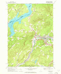 1971 Littleton1973 Print · USGSLittleton and the Ammonoosuc River valley appear here in the early 1970s as modern interstates began to intersect with older rail and river economies. Researchers can trace family sites at North Littleton Cemetery or follow the Boston and Maine line through Barrett.3 unique versions available
 - 1976 Map of Sherbrooke
 1976 Sherbrooke1976 Print · USGSThe northern Maine woods and Quebec’s Eastern Townships meet in this mid-century survey of the rugged international borderlands. Genealogists and historians can trace rail-and-river connections through Thetford Mines, follow the Dead River to Flagstaff Lake, or locate small border crossings at Stanhope and Beecher Falls.2 unique versions available
 - 1978 Map of Norton Port of Entry
 1978 Norton Port of Entry1978 Print · USGSThe international border at Vermont and Quebec comes into focus in the late seventies, centered on the crossing at Norton. Trace the path of the Canadian National rail line as it follows the Coaticook River past Stanhope.
 - 1978 Map of West of Norton Port of Entry
 1978 West of Norton Port of Entry1978 Print · USGSThe Vermont-Quebec borderlands appear in striking detail in the late seventies, showing the remote forested terrain along the international line. Researchers can trace the path of the Tomifobia River, locate the Fish Hatchery, and identify old routes like Mountain Road.
End of results
Showing maps 1-4 of 4
Top cities of Essex County
- Lunenburg historical maps
- Concord historical maps
- Brighton historical maps
- Canaan historical maps
- East Haven historical maps
- Guildhall historical maps
See more
Frequently asked questions
- What are the different types of historical maps available for Essex County?
- What is the oldest map of Essex County?
- Where can I purchase historical maps of Essex County for my home or office?
- Where can I download high-res historical maps of Essex County?
- Are there historical topographic maps available for Essex County?
- Is there historical aerial imagery available for Essex County?
- Where are historical maps of Essex County sourced from?