1980s Maps of Essex County, Vermont
Explore 23 historic maps of Essex County from the 1980s. These maps offer a rare glimpse into what life looked like during the 1980s — showing old roads, neighborhoods, homes, and landmarks that have changed or disappeared over time.
Whether you're researching your family's past, planning a metal detecting trip, or studying how Essex County's landscape evolved across the 1980s, these high-resolution maps are a powerful tool for exploring the history of this region.
- Focus on a specific era: All maps on this page are from the 1980s, giving you a focused view of this time period.
- See what’s changed: Compare century-old streets, trails, and buildings to today's modern landscape using overlays and satellite layers.
- Research with precision: Use these maps for genealogy, historical research, land use analysis, or educational projects.
- View, download, or print: Maps are fully viewable online in high resolution, and can be downloaded or printed for your own records.
Start exploring Essex County's history through authentic maps from the 1980s. This is your window into the past.
Essex County, VT maps
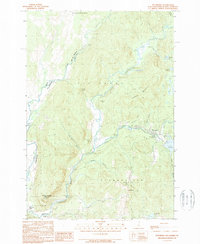
(23)- 1982 Map of Lancaster, 1983 Print
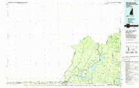
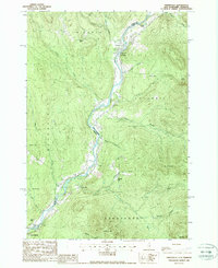
 1982 Lancaster1983 Print · USGSThe Connecticut River valley comes alive in the early eighties as a network of rail lines and riverside towns. Genealogists and historians can trace family-named hills and find local landmarks like St Matthews Ch, the Covered Bridge, and Riverside Cem.2 unique versions available
 - 1986 Map of Mount Washington
 1986 Mount Washington1986 Print · USGSThe northern New England highlands are shown here in the mid-eighties, centered on the high peaks and river valleys of the New Hampshire borderlands. Researchers can trace historic transportation lines like the Mount Washington Cog Railway and the Maine Central Railroad near Gorham and Lancaster.
 - 1986 Map of Groveton
 1986 Groveton1986 Print · USGSThe North Country's rugged borderlands come into focus in the mid-1980s, tracing the river-and-rail corridors of the Connecticut River valley. Genealogists and historians can locate family landmarks in North Stratford, Groveton, and Guildhall or trace the Canadian National RR.2 unique versions available
 - 1986 Map of Sherbrooke
 1986 Sherbrooke1986 Print · USGSThe Great North Woods of the mid-eighties appear in detail across this survey of the New Hampshire and Canadian borderlands. Researchers can trace the entire chain of the First Connecticut Lake through the fourth, alongside remote settlements like Pittsburg and Beecher Falls.2 unique versions available
 - 1988 Map of Seneca Mountain
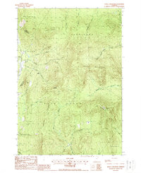 1988 Seneca Mountain1988 Print · USGSThe Northeast Kingdom's interior is captured here in the late 1980s, showing a landscape defined by the steep East Haven Range. Researchers can trace remote locales like Lost Nation and the headwaters of the Passumpsic River East Branch.
 - 1988 Map of Burke Mountain
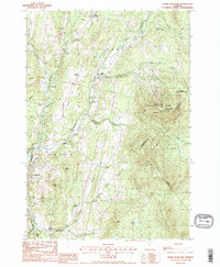 1988 Burke Mountain1988 Print · USGSThe Vermont highlands of the late eighties are defined here by the steep slopes of Burke Mtn and the working landscapes of the Caledonia and Essex county lines. Genealogists and hikers can trace old routes like Calendar Brook or locate historic hamlets including Burke Hollow and Red Village.2 unique versions available
 - 1988 Map of Bloomfield
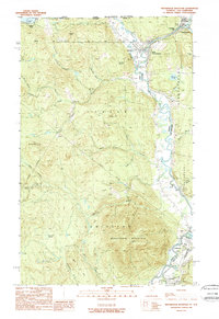
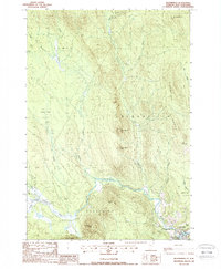 1988 Bloomfield1988 Print · USGSThe upper Connecticut River Valley comes into focus in the late eighties, showing the quiet border between Vermont and New Hampshire. Genealogists and hikers can trace the geography around Bloomfield, from the Yellow Bogs to the summits of Potash Mtn and French Mtn.
 - 1988 Map of Stratford
 1988 Stratford1988 Print · USGSThe upper Connecticut River valley comes to life in the late eighties, capturing the border communities of North Stratford and Maidstone in high detail. Genealogists and historians can trace family-named sites like Masons, old transport routes including the Old RR Grade, and remote water bodies like Stratford Bog Pond.
 - 1988 Map of Tinkerville
 1988 Tinkerville1988 Print · USGSThe Upper Connecticut River valley at the New Hampshire-Vermont border reveals its late-twentieth-century rural character here. Researchers can trace the riverfront settlements of Lemington and Tinkerville or locate landmarks like the Columbia Bridge and Wallace Pond.3 unique versions available
 - 1988 Map of Maidstone Lake
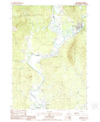
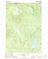 1988 Maidstone Lake1988 Print · USGSThe Northeast Kingdom's transition from timber industry to recreation is visible in this late-century survey of the Connecticut River valley. Trace the legacy of old industrial sites like Browns Mill and the Walker Dam (Site) near Maidstone Lake.
 - 1988 Map of Gallup Mills
 1988 Gallup Mills1988 Print · USGSNortheastern Vermont's timberlands are captured here in the late eighties, centered on the Moose River valley and its surrounding ridges. Researchers can trace the heritage of local logging sites and industry at Moccasin Mill (Site), the remote Gallup Mills settlement, and the Cem at Victory.2 unique versions available
 - 1988 Map of West Burke
 1988 West Burke1988 Print · USGSVermont's Northeast Kingdom shows its quiet, late-twentieth-century character in this detailed survey of the Burke and Newark area. Genealogists and hikers can trace the roads connecting Newark Street, Hartwellville, and the waters of Center Pond.2 unique versions available
 - 1988 Map of Spectacle Pond
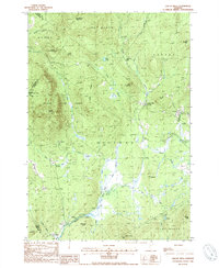
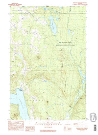
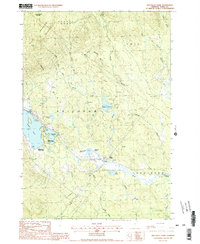 1988 Spectacle Pond1988 Print · USGSEssex County in the late 1980s reveals a landscape of massive forest tracts and the intricate headwaters of the Nulhegan River. Researchers can trace the boundaries of Avery's Gore, locate the remote settlement of Wenlock, and study the topography around Island Pond.2 unique versions available
 - 1988 Map of Stone Mountain
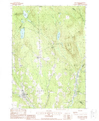
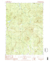 1988 Stone Mountain1988 Print · USGSEssex County in the late 1980s is shown here as a wilderness of granite peaks and forested brooks. Researchers can trace land use through a remote Cem, the Maidstone State Park boundary, and old trails near Stone Mountain and Cow Mtn Pond.
 - 1988 Map of Groveton
 1988 Groveton1988 Print · USGSThe upper Connecticut River valley is captured here in the late eighties, documenting the border towns of New Hampshire and Vermont. Genealogists and historians can trace the Old Railroad Grade, locate the Covered Bridge near Guildhall, and explore the industrial layout of Groveton.
 - 1988 Map of Island Pond
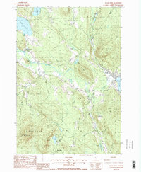 1988 Island Pond1988 Print · USGSThe Northeast Kingdom's highlands are captured here in the late eighties, showing the remote waters and peaks of Essex and Orleans counties. Genealogists and hikers can trace landmarks from the Bald Mtn Lookout Tower to the lakefront at Island Pond and the Cem near East Charleston.2 unique versions available
 - 1988 Map of Mount Washington, 1989 Print
 1988 Mount Washington1989 Print · USGSThe New Hampshire high country in the late 1980s is defined by its iconic peaks and the legacy of mountain tourism. Trace the routes of the historic Mount Washington Cog Railway and the Maine Central RR through the gaps of Crawford Notch State Park.
 - 1989 Map of Pittsburg
 1989 Pittsburg1989 Print · USGSNorthern New Hampshire's river-border country is captured here during the late eighties, showing the headwaters of the Connecticut River. Researchers can trace the varied terrain of Tabor Notch, the infrastructure of Lake Francis, and remote settlements like Pittsburg and Clarksville.3 unique versions available
 - 1989 Map of Morgan Center
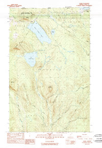
 1989 Morgan Center1989 Print · USGSVermont's northern border country is captured here in the late eighties, showing the remote woodlands and glacial ponds along the Canadian line. Genealogists and local historians can locate the Morgan Center settlement, the local Cem, and family-named landmarks like Page Hill or Mead Hill.2 unique versions available
 - 1989 Map of Averill
 1989 Averill1989 Print · USGSThe Essex County borderlands in the late eighties are defined by the massive waters of Great Averill Pond and the surrounding timberlands. Trace the remote logging history of the Vermont border through Camp No 21 and the waters of Forest Lake.2 unique versions available
 - 1989 Map of Monadnock Mountain
 1989 Monadnock Mountain1989 Print · USGSThe northern borderlands of Vermont and New Hampshire come into focus in the late eighties, centered on the Connecticut River valley. Genealogists can trace the rural layout of Beecher Falls, Stewartstown, and Canaan near the Canada line.
 - 1989 Map of Lovering Mountain
 1989 Lovering Mountain1989 Print · USGSThe northern reaches of the Connecticut River valley are captured here in the late eighties as they cross from New Hampshire into Vermont. Researchers can trace local landmarks like Beaver Brook Falls, the Mohawk River, and the settlement of Stewartstown Hollow.2 unique versions available
 - 1989 Map of Norton Pond
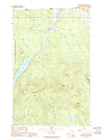 1989 Norton Pond1989 Print · USGSThe Vermont-Quebec borderlands come into focus in the late 1980s, documenting the remote woods and waters of Essex County. Genealogists and historians can trace local landmarks like Norton, the shores of Norton Pond, and the Drive-In Theater.
End of results
Showing maps 1-23 of 23
Top cities of Essex County
- Lunenburg historical maps
- Concord historical maps
- Brighton historical maps
- Canaan historical maps
- East Haven historical maps
- Guildhall historical maps
See more
Frequently asked questions
- What are the different types of historical maps available for Essex County?
- What is the oldest map of Essex County?
- Where can I purchase historical maps of Essex County for my home or office?
- Where can I download high-res historical maps of Essex County?
- Are there historical topographic maps available for Essex County?
- Is there historical aerial imagery available for Essex County?
- Where are historical maps of Essex County sourced from?