1990s Maps of Orange County, Vermont
Explore 5 historic maps of Orange County from the 1990s. These maps offer a rare glimpse into what life looked like during the 1990s — showing old roads, neighborhoods, homes, and landmarks that have changed or disappeared over time.
Whether you're researching your family's past, planning a metal detecting trip, or studying how Orange County's landscape evolved across the 1990s, these high-resolution maps are a powerful tool for exploring the history of this region.
- Focus on a specific era: All maps on this page are from the 1990s, giving you a focused view of this time period.
- See what’s changed: Compare century-old streets, trails, and buildings to today's modern landscape using overlays and satellite layers.
- Research with precision: Use these maps for genealogy, historical research, land use analysis, or educational projects.
- View, download, or print: Maps are fully viewable online in high resolution, and can be downloaded or printed for your own records.
Start exploring Orange County's history through authentic maps from the 1990s. This is your window into the past.
Orange County, VT maps
(5)- 1996 Map of Piermont, 2001 Print
 1996 Piermont2001 Print · USGSThe Connecticut River valley and the western edge of the White Mountains are shown here in the mid-nineties. You can trace the Appalachian National Scenic Trail past Mount Cube or locate family plots at Cedar Grove Cemetery and Dame Hill Cemetery.
 - 1996 Map of Lyme, 2001 Print
 1996 Lyme2001 Print · USGSThe Upper Valley river towns of Lyme and Thetford are captured here in the mid-nineties, showing the rural character of the Vermont and New Hampshire border. Researchers can locate family landmarks like the Thetford Academy, the Covered Bridge, and the Wilmot Cem near High Peak.
 - 1997 Map of Hancock, 2000 Print
 1997 Hancock2000 Print · USGSThe White River valley in central Vermont appears here in the late nineties, showing the vital road links between Granville and Hancock. Researchers can locate several family burial sites including Elmwood Cem and South Hollow Cem, or trace the remote Boyden Trail.
 - 1997 Map of Warren, 2000 Print
 1997 Warren2000 Print · USGSThe Mad River valley in the late twentieth century reveals a landscape of high-elevation farming and growing mountain recreation. Genealogists and hikers can trace old routes through Roxbury Gap, locate the historic Covered Bridge in Warren, and identify family sites near East Warren.
 - 1999 Map of Woodsville, 2000 Print
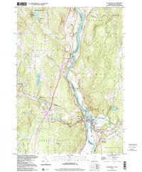 1999 Woodsville2000 Print · USGSThe upper Connecticut River valley at the turn of the millennium shows the enduring rail-and-river geography of the New Hampshire-Vermont border. Genealogists can locate family landmarks like St Josephs Cem, the Cottage Hospital, and the Covered Bridge at Woodsville.
End of results
Showing maps 1-5 of 5
Top cities of Orange County
- Randolph historical maps
- Williamstown historical maps
- Newbury historical maps
- Tunbridge historical maps
- Brookfield historical maps
- Strafford historical maps
See more
Frequently asked questions
- What are the different types of historical maps available for Orange County?
- What is the oldest map of Orange County?
- Where can I purchase historical maps of Orange County for my home or office?
- Where can I download high-res historical maps of Orange County?
- Are there historical topographic maps available for Orange County?
- Is there historical aerial imagery available for Orange County?
- Where are historical maps of Orange County sourced from?