Old Maps of Orange County, Vermont for Metal Detecting
Plan your next treasure hunt with 95 historic maps of Orange County. Find old homesites, ghost towns, trails, and gathering spots that may be lost to time — perfect for identifying promising metal detecting locations.
- Locate forgotten sites: Uncover places like long-lost settlements, abandoned rail lines, or gathering spots.
- Plan better hunts: Use map overlays combined with LiDAR or satellite views to narrow in on historically rich areas.
- Made for detectorists: Thousands of hobbyists use these maps to discover relics, coins, and hidden history.
Use these historic maps to boost your research and find new opportunities beneath the surface of Orange County.
Orange County, VT maps
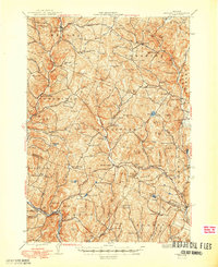
(95)- 1896 Map of Strafford
 1896 Strafford1896 Print · USGSOrange County and the upper White River valley are seen here during the height of the Vermont copper mining era. Local historians can locate specific operations like Copper Flat and Copperfield, or trace the rural landscape near South Strafford and Rices Mills.6 unique versions available
 - 1915 Map of Rochester, 1963 Print
 1915 Rochester1963 Print · USGSThe Green Mountains in the early twentieth century were a landscape of remote hollow schools and narrow valley settlements. Genealogists and historians can trace old property lines and landmarks like the Williams Mine, Hancock Tunnel, and the Texas School.
 - 1917 Map of Rochester
 1917 Rochester1917 Print · USGSThe Green Mountains in the mid-1910s reveal a network of isolated valley settlements and high-altitude gaps. Genealogists and hikers can trace old mountain schools like Corner School and remote landmarks such as Bingo Camp and the Hancock Tunnel.5 unique versions available
 - 1919 Map of Royalton
 1919 Royalton1919 Print · USGSCentral Vermont in the aftermath of the Great War reveals a landscape of thriving hill farms and river-valley rail towns. Genealogists can trace family roots through numerous rural landmarks like Waldo Corners, Wilson School, and the Central Vermont R.R. corridor.
 - 1919 Map of Lincoln Mountain, 1953 Print
 1919 Lincoln Mountain1953 Print · USGSThe Mad River valley and the high Green Mountain ridges are captured here during the first decades of the twentieth century. Genealogists and historians can locate numerous district schoolhouses like Robinson School and trace the timber-and-rail economy near the Central Vermont line.2 unique versions available
 - 1920 Map of Lincoln Mountain
 1920 Lincoln Mountain1920 Print · USGSThe Green Mountain summits and surrounding hill towns of central Vermont are captured here just after the Great War. Genealogists and local historians can trace old homesteads, early district schools like Gore School, and mountain landmarks such as Battell Lodge.
 - 1921 Map of Lincoln Mountain
 1921 Lincoln Mountain1921 Print · USGSThe Green Mountains in the early twentieth century are seen here in a detailed survey of high-elevation peaks and rural townships. Trace the early Green Mountain Trail past Battell Lodge or locate vanished hillside schoolhouses like Jerusalem School and Alder Hill School.5 unique versions available
 - 1922 Map of Barre
 1922 Barre1922 Print · USGSCentral Vermont in the early 1920s is revealed as a bustling landscape of granite quarries, hillside farms, and the historic Norwich University campus. Genealogists and historians can trace district schoolhouses, remote cemeteries like West Hill Cemetery, and industrial landmarks including the Talc Mine and numerous quarries.
 - 1924 Map of Barre
 1924 Barre1924 Print · USGSVermont's granite country and the Dog River valley are captured here in the mid-1920s, showing the early industrial roots of the region. Researchers can locate dozens of district schools, the Norwich University campus, and local industry sites like the Washington Granite Co and the Talc Mine.5 unique versions available
 - 1924 Map of Randolph
 1924 Randolph1924 Print · USGSMid-Vermont in the mid-1920s shows a landscape of river-valley commerce and mountain quarrying along the Central Vermont line. Genealogists can trace dozens of rural schoolhouses like Lost Nation School and Old Stone School, or locate the Bethel Granite Quarry.
 - 1926 Map of Randolph
 1926 Randolph1926 Print · USGSCentral Vermont in the mid-1920s was a landscape of river-valley rail hubs and upland hill farms. Genealogists can trace family names through dozens of schoolhouses like the Old Stone School or locate industrial sites like the Bethel Granite Quarry.5 unique versions available
 - 1931 Map of Mt. Cube
 1931 Mt. Cube1931 Print · USGSThe Connecticut River valley and the foothills of the White Mountains are shown here as they appeared in the early 1930s. Genealogists and hikers can trace the Appalachian Trail, locate rural schools like Blood Brook Sch, or find family sites near Quinttown.3 unique versions available
 - 1931 Map of Woodsville
 1931 Woodsville1931 Print · USGSThe Upper Connecticut River Valley in the early 1930s reveals a landscape of riverside rail towns and debated state boundaries. Genealogists and historians can trace the foundations of local life through labels like the North Monroe Ch, Blackmount Sta, and the County Poor Farm.
 - 1933 Map of Mt. Cube
 1933 Mt. Cube1933 Print · USGSThe Upper Connecticut River valley is shown in the early thirties, where rail and river networks linked New Hampshire and Vermont. Genealogists and local historians can trace schoolhouses like Stetson Sch, the remote Quinttown settlement, and the historic Mt Cube House.6 unique versions available
 - 1935 Map of Woodsville
 1935 Woodsville1935 Print · USGSThe Connecticut River valley in the mid-1930s is captured here in detail along the Vermont-New Hampshire border. Researchers can trace the legacy of local institutions and transport at the County Poor Farm, the Blackmount Sta rail stop, and The Oxbow.5 unique versions available
 - 1941 Map of Woodsville
 1941 Woodsville1941 Print · USGSThe Connecticut River valley was a bustling corridor of granite quarries and rail junctions just before the war. You can trace the legacy of local industry and education through landmarks like Gibson Quarry, the County Poor Farm, and Town Farm Sch.4 unique versions available
 - 1944 Map of Strafford, 1949 Print
 1944 Strafford1949 Print · USGSVermont's mining and rural heritage are frozen in time on this mid-century survey of the hills between the White and Ompompanoosuc Rivers. Genealogists and historians can trace the foundations of Strafford, locate the Joseph Smith Monument, or find industrial sites like the Elizabeth Mine.5 unique versions available
 - 1947 Map of Corinth
 1947 Corinth1947 Print · USGSThe granite quarrying region of Vermont is captured here just after the war, showing the industrial density of the hills. Genealogists can trace family roots through numerous local landmarks like Wilson Cem, Miles Sch, and settlements such as Goose Green and Websterville.
 - 1948 Map of East Barre
 1948 East Barre1948 Print · USGSCentral Vermont's quarrying and timber lands are captured here just after the war, showing the industrial centers of the Knox Mountains area. Genealogists can trace family roots through numerous remote burial grounds like Hutchinson Cem and schoolhouses such as Quarry Sch.2 unique versions available
 - 1950 Map of Glens Falls
 1950 Glens Falls1950 Print · USGSThe Adirondacks and the Green Mountains meet in this mid-century survey of the New York and Vermont borderlands. Researchers can trace the industrial rail corridors of the Rutland RR and Delaware & Hudson RR connecting Glens Falls, Rutland, and the shores of Lake George.
 - 1950 Map of Lake Champlain
 1950 Lake Champlain1950 Print · USGSThe Lake Champlain valley and its surrounding peaks are captured in detail during the late 1940s, showing the vital rail and road connections between New York and Vermont. Researchers can trace the routes of the Central Vermont Railway or locate old industrial centers like Mineville and Witherbee.2 unique versions available
 - 1956 Map of Glens Falls, 1968 Print
 1956 Glens Falls1968 Print · USGSUpper New York and the Vermont mountains are captured here in the mid-fifties, showing the rugged rail-and-river network of the Northeast. Researchers can trace the paths of the Delaware and Hudson RR and Rutland RR as they wind through valley towns like Poultney and Whitehall.3 unique versions available
 - 1957 Map of East Barre, 1959 Print
 1957 East Barre1959 Print · USGSThe granite industry and deep woodland of central Vermont are on display in the mid-fifties. Genealogists can trace family lines through Wilson Cem or locate the Quarry Sch near Upper Graniteville.4 unique versions available
 - 1957 Map of Randolph, 1960 Print
 1957 Randolph1960 Print · USGSThe White River valley in the late fifties shows a landscape defined by its rail-and-river network and agricultural education roots. Researchers can trace local genealogy through sites like Braintree Ch and Fairview Cem or locate vanished civic landmarks like the Drive-in Theater.3 unique versions available
 - 1957 Map of Barre, 1960 Print
 1957 Barre1960 Print · USGSCentral Vermont’s rugged spine is captured in the late fifties, showcasing the tight-knit valley towns and mountain camps of Washington County. Genealogists and historians can trace the Central Vermont rail line, find old schools like No 9 Sch, and locate the historic State Fish Hatchery near Roxbury.3 unique versions available
Showing maps 1-25 of 95
Top cities of Orange County
- Randolph historical maps
- Williamstown historical maps
- Newbury historical maps
- Tunbridge historical maps
- Brookfield historical maps
- Strafford historical maps
See more
Frequently asked questions
- What are the different types of historical maps available for Orange County?
- What is the oldest map of Orange County?
- Where can I purchase historical maps of Orange County for my home or office?
- Where can I download high-res historical maps of Orange County?
- Are there historical topographic maps available for Orange County?
- Is there historical aerial imagery available for Orange County?
- Where are historical maps of Orange County sourced from?