1990s Maps of Washington County, Vermont
Explore 6 historic maps of Washington County from the 1990s. These maps offer a rare glimpse into what life looked like during the 1990s — showing old roads, neighborhoods, homes, and landmarks that have changed or disappeared over time.
Whether you're researching your family's past, planning a metal detecting trip, or studying how Washington County's landscape evolved across the 1990s, these high-resolution maps are a powerful tool for exploring the history of this region.
- Focus on a specific era: All maps on this page are from the 1990s, giving you a focused view of this time period.
- See what’s changed: Compare century-old streets, trails, and buildings to today's modern landscape using overlays and satellite layers.
- Research with precision: Use these maps for genealogy, historical research, land use analysis, or educational projects.
- View, download, or print: Maps are fully viewable online in high resolution, and can be downloaded or printed for your own records.
Start exploring Washington County's history through authentic maps from the 1990s. This is your window into the past.
Washington County, VT maps
(6)- 1997 Map of Lincoln, 2000 Print
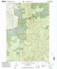 1997 Lincoln2000 Print · USGSNear the close of the twentieth century, the mountain towns of Lincoln and South Lincoln remained deeply tied to the surrounding peaks. Genealogists and hikers can trace the LONG TRAIL past Mt Abraham or locate family sites like Lee Cem and the Lincoln Community Sch.
 - 1997 Map of Warren, 2000 Print
 1997 Warren2000 Print · USGSThe Mad River valley in the late twentieth century reveals a landscape of high-elevation farming and growing mountain recreation. Genealogists and hikers can trace old routes through Roxbury Gap, locate the historic Covered Bridge in Warren, and identify family sites near East Warren.
 - 1997 Map of Waitsfield, 2000 Print
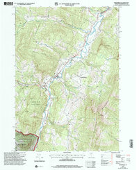 1997 Waitsfield2000 Print · USGSThe Mad River valley and its surrounding mountain forests appear here in the late nineties, capturing a classic Vermont landscape of valley farms and steep timber. Genealogists and local historians can trace family plots at Wait Cem, locate Our Lady of the Snows Ch, or find the historic Covered Bridge.
 - 1997 Map of Mount Ellen, 2000 Print
 1997 Mount Ellen2000 Print · USGSVermont's Green Mountains reveal a landscape of high peaks and winter resorts during the late nineties. Genealogists and hikers can trace the Long Trail past high summits to historic burial grounds like Little Ireland Cem and Jerusalem Cem.
 - 1999 Map of Montpelier, 2000 Print
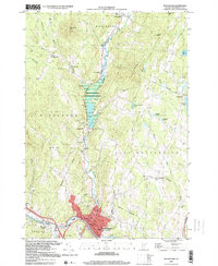 1999 Montpelier2000 Print · USGSMontpelier and the surrounding hills are captured in the late 1990s, showcasing the capital's layout and its river-valley geography. Researchers can trace the grounds of the State Capitol, locate the Green Mount Cemetery, and find rural landmarks like The Old Meetinghouse Ch.
 - 1999 Map of Mount Worcester, 2000 Print
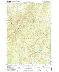 1999 Mount Worcester2000 Print · USGSVermont's Green Mountain spine near the end of the century is defined by the high peaks of the Worcester Mountains and the winding North Branch. Researchers can trace the protected boundaries of Putnam State Forest and find remote landmarks like Moss Glen Falls and Hardwood Pond.
End of results
Showing maps 1-6 of 6
Top cities of Washington County
- Barre historical maps
- Montpelier historical maps
- Northfield historical maps
- Waterbury historical maps
- Berlin historical maps
- East Montpelier historical maps
See more
Frequently asked questions
- What are the different types of historical maps available for Washington County?
- What is the oldest map of Washington County?
- Where can I purchase historical maps of Washington County for my home or office?
- Where can I download high-res historical maps of Washington County?
- Are there historical topographic maps available for Washington County?
- Is there historical aerial imagery available for Washington County?
- Where are historical maps of Washington County sourced from?