1940s Maps of Duxbury, Vermont
Explore 5 historic maps of Duxbury from the 1940s. These maps offer a rare glimpse into what life looked like during the 1940s — showing old roads, neighborhoods, homes, and landmarks that have changed or disappeared over time.
Whether you're researching your family's past, planning a metal detecting trip, or studying how Duxbury's landscape evolved across the 1940s, these high-resolution maps are a powerful tool for exploring the history of this region.
- Focus on a specific era: All maps on this page are from the 1940s, giving you a focused view of this time period.
- See what’s changed: Compare century-old streets, trails, and buildings to today's modern landscape using overlays and satellite layers.
- Research with precision: Use these maps for genealogy, historical research, land use analysis, or educational projects.
- View, download, or print: Maps are fully viewable online in high resolution, and can be downloaded or printed for your own records.
Start exploring Duxbury's history through authentic maps from the 1940s. This is your window into the past.
Duxbury, VT maps
(5)- 1944 Map of Montpelier
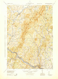 1944 Montpelier1944 Print · USGSCentral Vermont in the mid-1940s is mapped here with a focus on its mountain settlements and river valley corridors. Genealogists can trace family roots through numerous district schools like Loomis Hill Sch and the location of the Talc Mine.
 - 1944 Map of Camels Hump
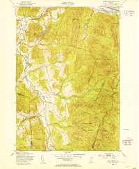
 1944 Camels Hump1944 Print · USGSThe Green Mountains at the height of the war era show a landscape defined by valley settlements and military expansion. You can trace the Central Vermont rail line through Bolton or find vanished rural schoolhouses like Ricker Sch and Phillips Sch.
 - 1948 Map of Huntington, 1953 Print
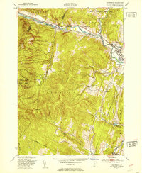
 1948 Huntington1953 Print · USGSThe Huntington River valley and the heights of the Green Mountains are shown in the late 1940s before modern development. Hikers and historians can trace The Long Trail to remote camps like Gorham Lodge or find rural landmarks like Fiddock Sch.4 unique versions available
 - 1948 Map of Waterbury, 1953 Print
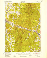
 1948 Waterbury1953 Print · USGSWashington County enters the post-war era as a landscape of deep river valleys and high forest ridges. Genealogists can trace family footprints near Waterbury, find the State Hospital, or locate remote mountain schools like Phillips Sch and Durkee Sch.4 unique versions available
 - 1948 Map of Camels Hump, 1954 Print
 1948 Camels Hump1954 Print · USGSThe Green Mountains of the late 1940s are defined by the Winooski River corridor and the high peaks of the range. Genealogists and local historians can trace the foundations of mountain life through Old Round Ch, the Machine Gun Sch, and the rail stops of the Central Vermont line.5 unique versions available
End of results
Showing maps 1-5 of 5
Top cities near Duxbury
- Essex historical maps
- Williston historical maps
- Montpelier historical maps
- Northfield historical maps
- Waterbury historical maps
- Stowe historical maps
See more
Top neighborhoods of Duxbury
Frequently asked questions
- What are the different types of historical maps available for Duxbury?
- What is the oldest map of Duxbury?
- Where can I purchase historical maps of Duxbury for my home or office?
- Where can I download high-res historical maps of Duxbury?
- Are there historical topographic maps available for Duxbury?
- Is there historical aerial imagery available for Duxbury?
- Where are historical maps of Duxbury sourced from?