1900s (20th Century) Maps of Stratton, Vermont
Explore 26 historic maps of Stratton from the 1900s (20th Century). These maps offer a rare glimpse into what life looked like during the 1900s — showing old roads, neighborhoods, homes, and landmarks that have changed or disappeared over time.
Whether you're researching your family's past, planning a metal detecting trip, or studying how Stratton's landscape evolved across the 1900s, these high-resolution maps are a powerful tool for exploring the history of this region.
- Focus on a specific era: All maps on this page are from the 1900s, giving you a focused view of this time period.
- See what’s changed: Compare century-old streets, trails, and buildings to today's modern landscape using overlays and satellite layers.
- Research with precision: Use these maps for genealogy, historical research, land use analysis, or educational projects.
- View, download, or print: Maps are fully viewable online in high resolution, and can be downloaded or printed for your own records.
Start exploring Stratton's history through authentic maps from the 1900s. This is your window into the past.
Stratton, VT maps
(26)- 1900 Map of Equinox
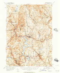
 1900 Equinox1900 Print · USGSBennington County’s valley corridor and high mountain notches are captured here in the final years of the nineteenth century. Researchers can trace the early rail-and-river network through Manchester Depot, identify old homesteads at Kelley Stand, and locate vanished landmarks like Fayville.7 unique versions available
 - 1903 Map of Mettawee
 1903 Mettawee1903 Print · USGSThe New York and Vermont borderlands come alive in this turn-of-the-century survey of the Mettawee Valley. Genealogists can trace family footprints from Middletown Springs down to the Saratoga and Champlain Canal at Fort Ann.2 unique versions available
 - 1943 Map of Brattleboro
 1943 Brattleboro1943 Print · USGSSouthern Vermont and the Massachusetts border area appear in this mid-century survey as a landscape of timbered peaks and river-connected villages. Genealogists can trace family roots through markers like Arms Cem or follow the rails at Dummerston Sta and Putney Sta.
 - 1948 Map of Albany, 1951 Print
 1948 Albany1951 Print · USGSThe Hudson and Connecticut River valleys are captured here in the late 1940s, showing the vital rail and water corridors of the Northeast. You can trace the Boston and Maine tracks past Mt Greylock or locate early settlements like Great Barrington and Bennington.
 - 1950 Map of Glens Falls
 1950 Glens Falls1950 Print · USGSThe Adirondacks and the Green Mountains meet in this mid-century survey of the New York and Vermont borderlands. Researchers can trace the industrial rail corridors of the Rutland RR and Delaware & Hudson RR connecting Glens Falls, Rutland, and the shores of Lake George.
 - 1954 Map of Wilmington, 1957 Print
 1954 Wilmington1957 Print · USGSSouthern Vermont's Windham County is shown here in the mid-1950s, a landscape defined by industrial water management and rural hamlets. Researchers can trace the Hoosac Tunnel and Wilmington RR and find family names at Riverview Cem or Hathaway Cem.5 unique versions available
 - 1956 Map of Albany, 1968 Print
 1956 Albany1968 Print · USGSThe industrial heart of the Northeast is revealed in the mid-1950s, from the Hudson Valley to the Connecticut River. Researchers can trace the legacy of the Quabbin Reservoir, locate Westover Air Force Base, or follow the Rutland RR through the Green Mountains.2 unique versions available
 - 1956 Map of Glens Falls, 1968 Print
 1956 Glens Falls1968 Print · USGSUpper New York and the Vermont mountains are captured here in the mid-fifties, showing the rugged rail-and-river network of the Northeast. Researchers can trace the paths of the Delaware and Hudson RR and Rutland RR as they wind through valley towns like Poultney and Whitehall.3 unique versions available
 - 1957 Map of Albany
 1957 Albany1957 Print · USGSThe Tri-State region and Connecticut River Valley are captured here during a period of significant postwar growth and infrastructure expansion. Genealogists and historians can trace the rail-and-river economy through landmarks like the Boston and Maine railroad, Quabbin Reservoir, and Westover Air Force Base.
 - 1957 Map of Londonderry, 1959 Print
 1957 Londonderry1959 Print · USGSThe Green Mountains in the late fifties reveal a transition from traditional timberlands to a burgeoning ski destination. Researchers can trace the Long Trail, locate family plots at Riverside Cem, and find landmarks like the Daniel Webster Historical Monument.3 unique versions available
 - 1959 Map of Glens Falls
 1959 Glens Falls1959 Print · USGSUpper New York and Vermont are captured here during the late 1950s, a period of transition for these mountain communities. Researchers can trace the legacy of the region's river-and-rail economy through landmarks like Lake George, Saratoga Springs, and Killington Peak.2 unique versions available
 - 1959 Map of Albany
 1959 Albany1959 Print · USGSThe Hudson and Connecticut River valleys are captured here during the late fifties, showing the region's dense rail networks and massive water projects. Researchers can trace the New York State Thruway or locate local landmarks like Mt Greylock and the Quabbin Reservoir.
 - 1962 Map of Albany
 1962 Albany1962 Print · USGSThe Hudson and Connecticut River valleys meet the Green Mountains and Berkshires in this mid-century overview of the Northeast. Genealogists and historians can trace the industrial hearts of Albany and Springfield or locate features like Quabbin Reservoir and Westover Air Force Base.
 - 1964 Map of Glens Falls
 1964 Glens Falls1964 Print · USGSThe tri-state borderlands of New York, Vermont, and New Hampshire appear here in the mid-1960s. Researchers can trace the rail routes of the Rutland RR and find historic sites like Ticonderoga and Saratoga National Historical Park.
 - 1968 Map of Sunderland, 1972 Print
 1968 Sunderland1972 Print · USGSBennington County in the late sixties reveals a landscape where valley farming in Sunderland meets the high wilderness of the Green Mountains. Hikers and historians can trace the Appalachian Trail through remote settlements like East Kansas and Fayville.
 - 1985 Map of Claremont, 1986 Print
 1985 Claremont1986 Print · USGSUpper Valley and Green Mountain life are captured here in the mid-eighties, centered on the river-linked hubs of Claremont and Springfield. Trace old family routes and rail lines like the Boston & Maine RR, or locate properties near Lake Sunapee and Mount Ascutney State Park.2 unique versions available
 - 1986 Map of Glens Falls
 1986 Glens Falls1986 Print · USGSThe Upper Hudson Valley and Vermont borderlands come together in this mid-eighties survey of industrial river towns and mountain retreats. Genealogists and historians can trace the rail lines of the Delaware and Hudson Railway or locate landmarks like the Mount McGregor Correctional Facility and Saratoga Spa State Park.2 unique versions available
 - 1986 Map of Keene
 1986 Keene1986 Print · USGSThe tri-state borderlands of the Connecticut River Valley come alive in this mid-eighties survey of southern Vermont, New Hampshire, and Massachusetts. Genealogists and historians can trace rail-era villages like Ashuelot and Millers Falls alongside landmarks like Marlboro College and Monadnock Mountain.3 unique versions available
 - 1986 Map of Jamaica, 1987 Print
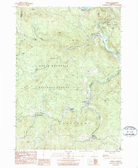 1986 Jamaica1987 Print · USGSWindham County life in the 1980s is centered on the West River valley and the high slopes of the Green Mountain range. Genealogists and historians can trace several village centers, from South Wardsboro to Wardsboro Center, along with local landmarks like Pikes Falls and Adam Pond.
 - 1986 Map of Stratton Mtn, 1987 Print
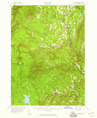
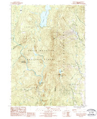
 1986 Stratton Mtn1987 Print · USGSWindham County's high ridges and glacial ponds are captured here in the mid-eighties as a vast wilderness and recreation hub. Hikers can trace the Appalachian Trail across Stratton Mountain or find old cemeteries and landmarks in Pike Hollow.3 unique versions available
 - 1986 Map of Mount Snow, 1987 Print
 1986 Mount Snow1987 Print · USGSThe Green Mountains in the mid-1980s reveal a landscape of high-altitude reservoirs and developing ski peaks. Genealogists and hikers can trace the remote reaches of Somerset and Searsburg or locate landmarks like Mount Snow and Haystack Pond.
 - 1989 Map of Glens Falls
 1989 Glens Falls1989 Print · USGSThe Upper Hudson Valley and the Vermont borderlands are captured here during the late eighties, showing a landscape of river-town industry and mountain recreation. Researchers can trace the Champlain Canal, the Delaware and Hudson RR, and historic sites like Saratoga National Historical Park.
 - 1997 Map of Jamaica, 2000 Print
 1997 Jamaica2000 Print · USGSWindham County at the close of the twentieth century shows a landscape defined by the rugged Green Mountains and the winding West River. Researchers can trace historic settlements from Jamaica to the small community of Podunk, while locating remote landmarks like South Hill Cem and Pikes Falls.
 - 1997 Map of Stratton Mountain, 2000 Print
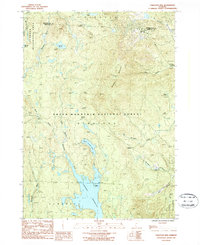
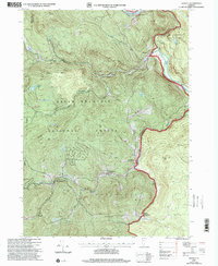
 1997 Stratton Mountain2000 Print · USGSThe Green Mountain National Forest is shown here during the late 1990s, where the Long and Appalachian Trails meet. Hikers and historians can locate the Daniel Webster Historical Monument and remote stops like Vondell Shelter or Stratton Pond.
 - 1997 Map of Sunderland, 2000 Print
 1997 Sunderland2000 Print · USGSBennington County’s mountain interior is captured here in the late 1990s, revealing the intersection of wilderness recreation and rural outposts. Hikers and historians can trace the Long Trail past Kelley Stand or locate old settlements like Fayville and East Kansas.
Showing maps 1-25 of 26
Top cities near Stratton
- Bennington historical maps
- Manchester historical maps
- Shaftsbury historical maps
- Pownal historical maps
- Manchester Center historical maps
- Manchester historical maps
See more
Frequently asked questions
- What are the different types of historical maps available for Stratton?
- What is the oldest map of Stratton?
- Where can I purchase historical maps of Stratton for my home or office?
- Where can I download high-res historical maps of Stratton?
- Are there historical topographic maps available for Stratton?
- Is there historical aerial imagery available for Stratton?
- Where are historical maps of Stratton sourced from?