1940s Maps of Tangier, Virginia
Explore 3 historic maps of Tangier from the 1940s. These maps offer a rare glimpse into what life looked like during the 1940s — showing old roads, neighborhoods, homes, and landmarks that have changed or disappeared over time.
Whether you're researching your family's past, planning a metal detecting trip, or studying how Tangier's landscape evolved across the 1940s, these high-resolution maps are a powerful tool for exploring the history of this region.
- Focus on a specific era: All maps on this page are from the 1940s, giving you a focused view of this time period.
- See what’s changed: Compare century-old streets, trails, and buildings to today's modern landscape using overlays and satellite layers.
- Research with precision: Use these maps for genealogy, historical research, land use analysis, or educational projects.
- View, download, or print: Maps are fully viewable online in high resolution, and can be downloaded or printed for your own records.
Start exploring Tangier's history through authentic maps from the 1940s. This is your window into the past.
Tangier, VA maps
(3)- 1942 Map of Tangier Island, 1962 Print
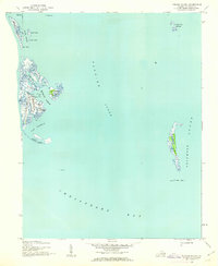 1942 Tangier Island1962 Print · USGSTangier Island at the start of the 1940s reveals a maritime community defined by its unique ridge-top settlements and marshy harbors. Genealogists and historians can trace residents living along Main Ridge and Canton Ridge, or locate landmarks like Mailboat Harbor and Watts Island.
 - 1943 Map of Tangier Island
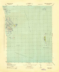 1943 Tangier Island1943 Print · USGSTangier Island and its surrounding waters are captured during the early 1940s, showing the isolated community's reliance on the bay. Researchers can trace family sites on Main Ridge or locate maritime landmarks like Mailboat Harbor and the Inner Light.
 - 1946 Map of Eastville, 1971 Print
 1946 Eastville1971 Print · USGSCoastal Virginia and the Outer Banks are captured here during a period of expanding naval and aerospace presence. Researchers can trace the path of the Penn Central railroad through Chincoteague and Modest Town, or locate landmarks like the Wright Brothers National Memorial.
End of results
Showing maps 1-3 of 3
Top cities near Tangier
- Crisfield historical maps
- Boston historical maps
- Pungoteague historical maps
- Bobtown historical maps
- Keller historical maps
- Harborton historical maps
See more
Frequently asked questions
- What are the different types of historical maps available for Tangier?
- What is the oldest map of Tangier?
- Where can I purchase historical maps of Tangier for my home or office?
- Where can I download high-res historical maps of Tangier?
- Are there historical topographic maps available for Tangier?
- Is there historical aerial imagery available for Tangier?
- Where are historical maps of Tangier sourced from?