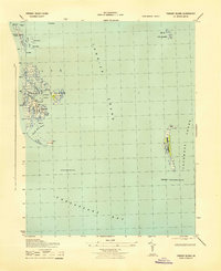
1943 Map of Tangier Island
USGS Topo · Published 1943About this map
Tangier and its surrounding marshlands are preserved here during the mid-war era, documenting the precarious geography of this isolated island community. The settlement is anchored by the Main Ridge, West Ridge, and Canton Ridge, reflecting a way of life deeply tied to the rhythms of the Chesapeake Bay. The maritime economy is evident through features like Mailboat Harbor and Oyster Creek, while navigation is supported by the Inner Light and the distant Tangier Sound Lighthouse. To the east, Watts Island and its own Watts Island Lighthouse stand as prominent landmarks in Pocomoke Sound. This survey captures the fragile coastal landforms, from the Sand Spit to the fragmented reaches of Goose Island, at a scale that highlights the intricate network of guts and marshes like Toms Gut and Fishing Gut.
Find a feature on this map
37 named features on this map. Tap any name to fly to it.
Don’t see what you’re looking for? This feature index may not catch every label — zoom into the map to look around manually.
Map Details
Editions of this 1943 Tangier Island Map
This is the sole edition of this map. No revisions or reprints were ever made.
Other maps of this area

1903 · Crisfield
USGS Topo · 1:62,500

1917 · Ewell
USGS Topo · 1:62,500

1920 · Crisfield
USGS Topo · 1:62,500

1942 · Chesconessex
USGS Topo · 1:31,680

1942 · Nandua Creek
USGS Topo · 1:24,000

1942 · Ewell
USGS Topo · 1:24,000

1942 · Great Fox Island
USGS Topo · 1:24,000

1942 · Tangier Island
USGS Topo · 1:24,000
1943 · Ewell
USGS Topo · 1:31,680

1943 · Pungoteague
USGS Topo · 1:31,680