
1917 Map of Ewell
USGS Topo · Published 1917About this map
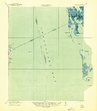
Smith Island and Tangier Island dominate this coastal survey, offering a detailed look at the water-dependent communities of the Chesapeake during the First World War. The map traces a complex network of marshes and guts, including Big Thorofare and Little Thorofare, which connect the isolated settlements of Ewell, Rhodes Point, and Tylerton. A clearly marked Steamboat Route cuts through Chesapeake Bay and Tangier Sound, highlighting the essential maritime transportation links that sustained these island outposts before the advent of modern bridge networks. Navigation is further defined by the Smith Point LH and Tangier Sound LH, landmarks critical to the mariners navigating these shallow coastal waters. The survey also captures the precise Boundary Line separating Maryland and Virginia, which bisects the marshlands and water bodies like Shanks Creek.
Find a feature on this map
37 named features on this map. Tap any name to fly to it.
Don’t see what you’re looking for? This feature index may not catch every label — zoom into the map to look around manually.
Map Details
Editions of this 1917 Ewell Map
2 editions found
Other maps of this area

1894 · Point Lookout
USGS Topo · 1:62,500

1898 · St. Marys
USGS Topo · 1:125,000

1903 · Crisfield
USGS Topo · 1:62,500

1903 · Bloodsworth Island
USGS Topo · 1:62,500

1903 · Deal Island
USGS Topo · 1:62,500

1906 · St. Marys
USGS Topo · 1:125,000

1912 · Point Lookout
USGS Topo · 1:62,500

1916 · Kilmarnock
USGS Topo · 1:48,000

1917 · Heathsville
USGS Topo · 1:48,000

1917 · Kilmarnock
USGS Topo · 1:62,500