
1903 Map of Bloodsworth Island
USGS Topo · Published 1903About this map
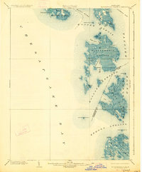
Bloodsworth Island No. 10 and its surrounding archipelago define this maritime landscape at the turn of the century, where the marshy fringes of the Chesapeake Bay meet the open waters of Tangier Sound. The map documents a fragile coastal environment long before modern erosion and rising tides significantly altered these landforms. Small fishing and crabbing outposts like Applegarth and Crocheron represent the isolated watermen communities of the era.
Find a feature on this map
54 named features on this map. Tap any name to fly to it.
Don’t see what you’re looking for? This feature index may not catch every label — zoom into the map to look around manually.
Map Details
Editions of this 1903 Bloodsworth Island Map
3 editions found
Historical Maps of Crocheron Through Time
88 maps found

1898 St. Marys
Dorchester County, MD

1903 Bloodsworth Island
Dorchester County, MD

1905 Crapo
Dorchester County, MD

1906 St. Marys
Dorchester County, MD

1942 Barren Island
Dorchester County, MD

1942 Blackwater River
Dorchester County, MD

1942 Bloodsworth Island
Dorchester County, MD

1942 Chicamacomico
Dorchester County, MD

1942 Golden Hill
Dorchester County, MD

1942 Honga
Dorchester County, MD

1942 Richland Point
Dorchester County, MD

1942 Sharps Island
Dorchester County, MD

1942 Wingate
Dorchester County, MD

1943 Barren Island
Dorchester County, MD

1943 Blackwater River
Dorchester County, MD

1943 Bloodsworth Island
Dorchester County, MD

1943 Chicamacomico
Dorchester County, MD

1943 Golden Hill
Dorchester County, MD

1943 Honga
Dorchester County, MD

1943 Richland Point
Dorchester County, MD

1943 Sharps Island
Dorchester County, MD

1943 Wingate
Dorchester County, MD

1944 Rhodesdale
Dorchester County, MD

1973 Bloodsworth Island
Dorchester County, MD

1973 Richland Point
Dorchester County, MD

1981 Golden Hill
Dorchester County, MD

1982 Blackwater River
Dorchester County, MD

1982 Chicamacomico River
Dorchester County, MD

1982 East Of Point Lookout
Dorchester County, MD

1982 Hudson
Dorchester County, MD

1982 Wingate
Dorchester County, MD

1984 Barren Island
Dorchester County, MD

1984 Honga
Dorchester County, MD

1988 Rhodesdale
Dorchester County, MD

2011 Barren Island
Dorchester County, MD

2011 Blackwater River
Dorchester County, MD

2011 Bloodsworth Island
Dorchester County, MD

2011 Chicamacomico River
Dorchester County, MD

2011 Golden Hill
Dorchester County, MD

2011 Honga
Dorchester County, MD

2011 Hudson
Dorchester County, MD

2011 Rhodesdale
Dorchester County, MD

2011 Richland Point
Dorchester County, MD

2011 Wingate
Dorchester County, MD

2014 Barren Island
Dorchester County, MD

2014 Blackwater River
Dorchester County, MD

2014 Bloodsworth Island
Dorchester County, MD

2014 Chicamacomico River
Dorchester County, MD

2014 East of Point Lookout (All Water)
Dorchester County, MD

2014 Golden Hill
Dorchester County, MD

2014 Honga
Dorchester County, MD

2014 Hudson
Dorchester County, MD

2014 Rhodesdale
Dorchester County, MD

2014 Richland Point
Dorchester County, MD

2014 Wingate
Dorchester County, MD

2016 Barren Island
Dorchester County, MD

2016 Blackwater River
Dorchester County, MD

2016 Chicamacomico River
Dorchester County, MD

2016 Golden Hill
Dorchester County, MD

2016 Honga
Dorchester County, MD

2016 Hudson
Dorchester County, MD

2016 Rhodesdale
Dorchester County, MD

2016 Wingate
Dorchester County, MD

2017 Bloodsworth Island
Dorchester County, MD

2017 East of Point Lookout (All Water)
Dorchester County, MD

2017 Richland Point
Dorchester County, MD

2019 Barren Island
Dorchester County, MD

2019 Blackwater River
Dorchester County, MD

2019 Bloodsworth Island
Dorchester County, MD

2019 Chicamacomico River
Dorchester County, MD

2019 East of Point Lookout (All Water)
Dorchester County, MD

2019 Golden Hill
Dorchester County, MD

2019 Honga
Dorchester County, MD

2019 Hudson
Dorchester County, MD

2019 Rhodesdale
Dorchester County, MD

2019 Richland Point
Dorchester County, MD

2019 Wingate
Dorchester County, MD

2023 Barren Island
Dorchester County, MD

2023 Blackwater River
Dorchester County, MD

2023 Bloodsworth Island
Dorchester County, MD

2023 Chicamacomico River
Dorchester County, MD

2023 East of Point Lookout (All Water)
Dorchester County, MD

2023 Golden Hill
Dorchester County, MD

2023 Honga
Dorchester County, MD

2023 Hudson
Dorchester County, MD

2023 Rhodesdale
Dorchester County, MD

2023 Richland Point
Dorchester County, MD

2023 Wingate
Dorchester County, MD