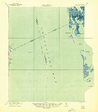
1917 Map of Ewell
USGS Topo · Published 1944About this map
Smith Island and its surrounding archipelagos define this maritime landscape at the intersection of the Chesapeake Bay and Tangier Sound. During this era, the isolated communities of Ewell, Rhodes Point, and Tylerton were connected to the mainland primarily by water, with a prominent Steamboat Route shown weaving between the Maryland and Virginia line. The intricate network of tidal guts and man-made passages like Indian Ditch and Tyler Ditch highlight a culture shaped by navigation and the harvesting of the bay.
Find a feature on this map
38 named features on this map. Tap any name to fly to it.
Don’t see what you’re looking for? This feature index may not catch every label — zoom into the map to look around manually.
Map Details
Editions of this 1917 Ewell Map
2 editions found

Other maps of this area

1894 · Point Lookout
USGS Topo · 1:62,500

1898 · St. Marys
USGS Topo · 1:125,000

1903 · Crisfield
USGS Topo · 1:62,500

1903 · Bloodsworth Island
USGS Topo · 1:62,500

1903 · Deal Island
USGS Topo · 1:62,500

1906 · St. Marys
USGS Topo · 1:125,000

1912 · Point Lookout
USGS Topo · 1:62,500

1916 · Kilmarnock
USGS Topo · 1:48,000

1917 · Heathsville
USGS Topo · 1:48,000

1917 · Kilmarnock
USGS Topo · 1:62,500