
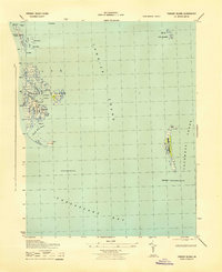
1942 Map of Nandua Creek
USGS Topo · Published 1952About this map
Hacks Neck dominates the eastern margin of this coastal survey, where the terrestrial landscape of Accomack County meets the expanse of the Chesapeake Bay. Mapped for the Army Map Service during the second World War, the sheet focuses on the intricate waterlogged geography of the Eastern Shore, highlighting the narrow inlets of Butcher Creek and Nandua Creek. Navigation in these shallow tidal waters is marked by the Pungoteague Creek Light, a critical landmark for mariners entering the bay from the various creeks. The interior of the neck shows a patchwork of forest and cleared land, with localized landmarks like The Sandhill and Milbys Pt providing reference points for researchers studying the mid-century shoreline before modern coastal changes altered the periphery of Back Creek.
Find a feature on this map
8 named features on this map. Tap any name to fly to it.
Don’t see what you’re looking for? This feature index may not catch every label — zoom into the map to look around manually.
Map Details
Editions of this 1942 Nandua Creek Map
This is the sole edition of this map. No revisions or reprints were ever made.
Other maps of this area

1903 · Crisfield
USGS Topo · 1:62,500

1917 · Ewell
USGS Topo · 1:62,500

1920 · Crisfield
USGS Topo · 1:62,500

1942 · Chesconessex
USGS Topo · 1:31,680

1942 · Tangier Island
USGS Topo · 1:24,000

1943 · Jamesville
USGS Topo · 1:31,680

1943 · Pungoteague
USGS Topo · 1:31,680
1943 · Tangier Island
USGS Topo · 1:31,680

1943 · Exmore
USGS Topo · 1:24,000

1943 · Richmond
USGS Topo · 1:250,000