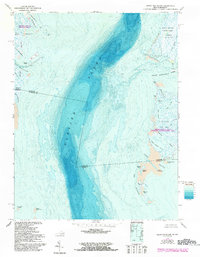
1968 Map of Great Fox Island
USGS Topo · Published 1992About this map
Tangier Sound dominates this hydrographic and topographic study of the Chesapeake Bay's intricate marshland archipelago. Spanning the Maryland and Virginia state line, the map documents the fragile geography of Smith Island and the Fox Islands before significant late-20th-century erosion. Small maritime settlements like Horse Hammock and Reach Hammock appear alongside vital navigation aids, such as the Light stations guiding vessels through Big Thorofare and Cedar Straits. The map's bathymetric data reveals the deep channels of the Little Annemessex River contrasting with the expansive shallows of Twitch Cove and Old House Cove. Large conservation zones are already established, including the Martin National Wildlife Refuge and Janes Island State Park, highlighting the transition of these islands from remote fishing outposts to protected natural landscapes.
Find a feature on this map
50 named features on this map. Tap any name to fly to it.
Don’t see what you’re looking for? This feature index may not catch every label — zoom into the map to look around manually.
Map Details
Editions of this 1968 Great Fox Island Map
3 editions found
Other maps of this area

1898 · St. Marys
USGS Topo · 1:125,000

1903 · Crisfield
USGS Topo · 1:62,500

1903 · Bloodsworth Island
USGS Topo · 1:62,500

1903 · Deal Island
USGS Topo · 1:62,500

1906 · St. Marys
USGS Topo · 1:125,000

1917 · Ewell
USGS Topo · 1:62,500

1920 · Crisfield
USGS Topo · 1:62,500

1942 · Chesconessex
USGS Topo · 1:31,680

1942 · Terrapin Sand Point
USGS Topo · 1:24,000

1942 · Kedges Straits
USGS Topo · 1:24,000