
1942 Map of Chesconessex
USGS Topo · Published 1942About this map
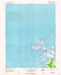
Pocomoke Sound dominates the northwestern expanse of this coastal chart, where the intricate salt marshes and tidal guts of Accomack County meet the open water. The landscape is defined by a dense archipelago of wetlands including Big Marsh, Tobacco Island, and Savage Island. Navigation through these shallow reaches is guided by the Beach Island Shoal Light, marking the transition from the sound into the more protected waters of Island Bay. On the southern mainland, the settlement of Chesconessex sits near the mouth of Chesconessex Creek, serving as a small hub for the local maritime economy. Further inland, Leatherbury Church stands as a primary community landmark, anchored by a benchmark at the road intersection. The map reveals a world of water-access points like The Thorofare and family-named landforms such as Russell I and Scott I, illustrating the deep connection between the residents and the surrounding estuaries.
Find a feature on this map
36 named features on this map. Tap any name to fly to it.
Don’t see what you’re looking for? This feature index may not catch every label — zoom into the map to look around manually.
Map Details
Editions of this 1942 Chesconessex Map
2 editions found
Other maps of this area

1903 · Crisfield
USGS Topo · 1:62,500

1920 · Crisfield
USGS Topo · 1:62,500

1931 · Accomac
USGS Topo · 1:48,000

1935 · Accomac
USGS Topo · 1:62,500

1942 · Nandua Creek
USGS Topo · 1:24,000

1942 · Great Fox Island
USGS Topo · 1:24,000

1942 · Tangier Island
USGS Topo · 1:24,000

1942 · Saxis
USGS Topo · 1:24,000

1942 · Parksley
USGS Topo · 1:24,000

1943 · Pungoteague
USGS Topo · 1:31,680