
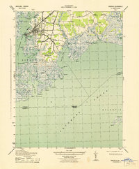
1942 Map of Saxis
USGS Topo · Published 1962About this map
Saxis Island and the surrounding marshlands of Pocomoke Sound define this 1942 survey of the Eastern Shore's tidal edge. The settlement of Saxis is accessible via a single road corridor that cuts through the Free School Marsh, connecting the island fishing community to inland villages like Sanford and Grotons. This landscape is heavily shaped by its water-dependent geography, featuring intricate networks of tidal creeks such as Messongo Creek and Holdens Creek that weave through the Richardson Marsh and Michael Marsh.
Find a feature on this map
59 named features on this map. Tap any name to fly to it.
Don’t see what you’re looking for? This feature index may not catch every label — zoom into the map to look around manually.
Map Details
Editions of this 1942 Saxis Map
This is the sole edition of this map. No revisions or reprints were ever made.
Other maps of this area

1903 · Crisfield
USGS Topo · 1:62,500

1903 · Deal Island
USGS Topo · 1:62,500

1920 · Crisfield
USGS Topo · 1:62,500

1942 · Chesconessex
USGS Topo · 1:31,680

1942 · Marion
USGS Topo · 1:24,000

1942 · Kingston
USGS Topo · 1:24,000

1942 · Mappsville
USGS Topo · 1:24,000

1942 · Parksley
USGS Topo · 1:24,000

1943 · Parksley
USGS Topo · 1:31,680
1943 · Crisfield
USGS Topo · 1:31,680