
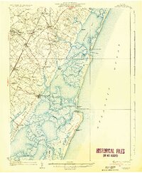
1935 Map of Accomac
USGS Topo · Published 1935About this map
The complex marshes and barrier islands of Virginia’s Eastern Shore define this mid-1930s landscape, centered on the county seat at Accomac. The interior reflects a well-established agricultural and social network, with rural gathering points such as the Oak Grove Chapel and Burton Ch situated among family-named landforms like Bailey Neck and Custis Neck. The arrival of the Pennsylvania Railroad significantly influenced local development, connecting mainland settlements like Onancock, Tasley, and Melfa to wider markets. Along the coast, the maritime economy is evident through the numerous channels and inlets, including the Wachapreague Inlet, which provides access to the Atlantic Ocean. This survey captures the maritime safety infrastructure of the era, noting multiple Coast Guard stations like the Metomkin Inlet C G Sta and Parramore Beach C G Sta, as well as recreational landmarks like the Sneed Beach Club.
Find a feature on this map
74 named features on this map. Tap any name to fly to it.
Don’t see what you’re looking for? This feature index may not catch every label — zoom into the map to look around manually.
Map Details
Editions of this 1935 Accomac Map
2 editions found
Other maps of this area

1903 · Crisfield
USGS Topo · 1:62,500

1920 · Crisfield
USGS Topo · 1:62,500

1931 · Accomac
USGS Topo · 1:48,000

1941 · Broadwater
USGS Topo · 1:62,500

1942 · Chesconessex
USGS Topo · 1:31,680

1942 · Mappsville
USGS Topo · 1:24,000

1942 · Little Machipongo Inlet
USGS Topo · 1:24,000

1942 · Nassawadox
USGS Topo · 1:24,000

1942 · Wallops Island
USGS Topo · 1:24,000

1942 · Parksley
USGS Topo · 1:24,000